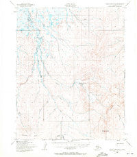
1950 Map of Bendeleben D-6
USGS Topo · Published 1972About this map
Serpentine Hot Springs serves as a remote focal point in this 1950s interior landscape of the Seward Peninsula. The terrain is defined by the Continental Divide and the towering height of Midnight Mountain, which dominates the southeastern quadrant. The drainage pattern is complex, with the Serpentine River and its numerous tributaries like Schlitz Creek and Mukluk Creek carving through the tundra.
Find a feature on this map
23 named features on this map. Tap any name to fly to it.
Don’t see what you’re looking for? This feature index may not catch every label — zoom into the map to look around manually.
Map Details
Editions of this 1950 Bendeleben D-6 Map
3 editions found
Other maps of this area

1950 · Bendeleben C-5
USGS Topo · 1:63,360

1950 · Bendeleben C-6
USGS Topo · 1:63,360

1950 · Bendeleben D-6
USGS Topo · 1:63,360

1950 · Teller
USGS Topo · 1:250,000

1950 · Bendeleben D-5
USGS Topo · 1:63,360

1950 · Bendeleben
USGS Topo · 1:250,000

1950 · Shishmaref
USGS Topo · 1:250,000

1950 · Shishmaref A-1
USGS Topo · 1:63,360

1950 · Kotzebue A-6
USGS Topo · 1:63,360

1950 · Kotzebue A-5
USGS Topo · 1:63,360