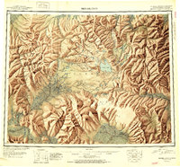
1951 Map of Bendeleben
USGS Topo · Published 1951About this map
Volcanic cones and glacial valleys define the Seward Peninsula in the early post-war era, as shown in this reconnaissance survey. The landscape is dominated by the Bendeleben Mountains and its namesake peak, Mt Bendeleben, which stands as a central landmark for the surrounding river systems. To the north, Serpentine Hot Springs provides a thermal focal point near the Serpentine River, while the center of the peninsula is marked by distinct geological features like the Camille Cone and Lost Jim Cone.
Find a feature on this map
200 named features on this map. Tap any name to fly to it.
Don’t see what you’re looking for? This feature index may not catch every label — zoom into the map to look around manually.
Map Details
Editions of this 1951 Bendeleben Map
2 editions found

Other maps of this area

1907 · Casadepaga
USGS Topo · 1:62,500

1948 · Norton Bay
USGS Topo · 1:250,000

1950 · Kotzebue A-1
USGS Topo · 1:63,360

1950 · Bendeleben C-5
USGS Topo · 1:63,360

1950 · Bendeleben A-6
USGS Topo · 1:63,360

1950 · Bendeleben B-5
USGS Topo · 1:63,360

1950 · Bendeleben A-4
USGS Topo · 1:63,360

1950 · Bendeleben C-1
USGS Topo · 1:63,360

1950 · Bendeleben C-3
USGS Topo · 1:63,360

1950 · Bendeleben B-6
USGS Topo · 1:63,360