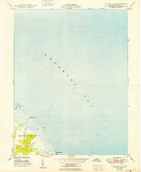
1949 Map of Bennetts Pier
USGS Topo · Published 1949About this map
Milford Neck dominates the landward portion of this coastal survey, where the low-lying terrain meets the expansive waters of Delaware Bay. The landscape is defined by the tidal interface of salt marshes and small waterways, notably Brockonbridge Gut winding near the shoreline. This 1949 edition captures a quiet stretch of the Delaware coast within District No 10, featuring isolated landing points and coastal settlements that served the local maritime and agricultural community before later 20th-century developments.
Find a feature on this map
8 named features on this map. Tap any name to fly to it.
Don’t see what you’re looking for? This feature index may not catch every label — zoom into the map to look around manually.
Map Details
Editions of this 1949 Bennetts Pier Map
2 editions found
Other maps of this area

1890 · Maurice Cove
USGS Topo · 1:62,500

1891 · Maurice Cove
USGS Topo · 1:62,500

1899 · Vineland
USGS Topo · 1:125,000

1918 · Cedar Creek
USGS Topo · 1:62,500

1918 · Cape Henlopen
USGS Topo · 1:62,500

1919 · Cedar Creek
USGS Topo · 1:62,500

1919 · Vineland
USGS Topo · 1:125,000

1934 · Bowers
USGS Topo · 1:48,000
1936 · Bowers
USGS Topo · 1:62,500

1937 · Cape Henlopen
USGS Topo · 1:62,500