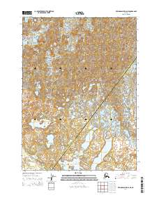
2014 Map of Bering Glacier A-8 NE
USGS Topo · Published 2014About this map
Glacial dynamics and complex hydraulic patterns define this region of the Yakutat City and Borough, where the massive Waxell Glacier flows toward the coast. The topography is dominated by the Central Medial Moraine Band, a striking geological feature indicating the historic convergence of multiple ice streams. Below the glacial face, the landscape transitions into a braided network of waterways, including the winding Okalee River and the Seal River, which drain toward the Tashalich Arm. The presence of the Linear Lakes suggests a terrain shaped by receding ice and persistent meltwater. This 2014 survey documents a volatile coastal environment at the boundary of the Valdez-Cordova Census Area, capturing the precise state of the glacial terminus and the evolving drainage basins that define this remote reach of the Alaskan panhandle.
Find a feature on this map
11 named features on this map. Tap any name to fly to it.
Don’t see what you’re looking for? This feature index may not catch every label — zoom into the map to look around manually.
Map Details
Editions of this 2014 Bering Glacier A-8 NE Map
This is the sole edition of this map. No revisions or reprints were ever made.
Other maps of this area

1950 · Bering Glacier
USGS Topo · 1:250,000

1951 · Bering Glacier
USGS Topo · 1:250,000

1959 · Bering Glacier
USGS Topo · 1:250,000
1984 · Bering Glacier A-8
USGS Topo · 1:63,360
1984 · Bering Glacier A-7
USGS Topo · 1:63,360
1985 · Bering Glacier B-8
USGS Topo · 1:63,360
1985 · Bering Glacier B-7
USGS Topo · 1:63,360
2014 · Bering Glacier B-8 SW
USGS Topo · 1:25,000
2014 · Bering Glacier B-8 SE
USGS Topo · 1:25,000
2014 · Bering Glacier A-8 NW
USGS Topo · 1:25,000