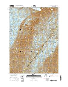
2016 Map of Bering Glacier B-7 SW
USGS Topo · Published 2016About this map
The massive Bering Glacier and Steller Glacier dominate this glacial landscape along the Gulf of Alaska coast. This 2016 survey documents the shifting ice fields and meltwater patterns in a remote region where the Valdez-Cordova Census Area meets the Yakutat City and Borough. A primary hydrological landmark here is Lake Safron, which sits at the terminus of these moving ice bodies. The map provides a precise record of the complex terminal moraines and outwash plains that characterize this ever-changing Alaskan wilderness. Researchers can examine the intricate contour lines to understand the massive scale of the glacial flow and the formation of temporary water bodies at the ice edge.
Find a feature on this map
10 named features on this map. Tap any name to fly to it.
Don’t see what you’re looking for? This feature index may not catch every label — zoom into the map to look around manually.
Map Details
Editions of this 2016 Bering Glacier B-7 SW Map
This is the sole edition of this map. No revisions or reprints were ever made.
Other maps of this area

1950 · Bering Glacier
USGS Topo · 1:250,000

1951 · Bering Glacier
USGS Topo · 1:250,000

1959 · Bering Glacier
USGS Topo · 1:250,000
1984 · Bering Glacier A-8
USGS Topo · 1:63,360
1984 · Bering Glacier A-7
USGS Topo · 1:63,360
1985 · Bering Glacier B-8
USGS Topo · 1:63,360
1985 · Bering Glacier B-7
USGS Topo · 1:63,360
2014 · Bering Glacier B-7 NW
USGS Topo · 1:25,000
2014 · Bering Glacier B-7 NE
USGS Topo · 1:25,000
2014 · Bering Glacier B-8 SE
USGS Topo · 1:25,000