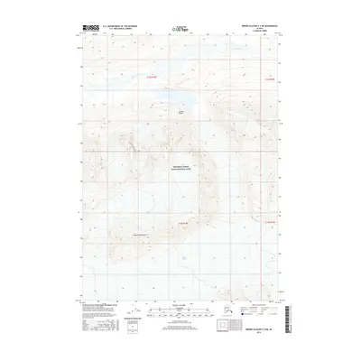
2016 Map of Bering Glacier C-4 NE
USGS Topo · Published 2016About this map
Wrangell-Saint Elias National Park preserves a massive stretch of glacial and mountainous wilderness in this 2016 survey. The terrain is dominated by the sprawling ice of the Tana Glacier to the south and the high peaks of the Granite Range at the center of the sheet. Part of the Chugach Mountains system, the landscape shows a complex network of drainages including Granite Creek, which flows through the northern sections of Township 13 South. This map provides a modern record of glacial extent and alpine topography in one of the most protected and least-disturbed regions of Alaska. The survey captures the intersection of high mountain ridges and massive ice flows before they descend toward the coast.
Find a feature on this map
9 named features on this map. Tap any name to fly to it.
Don’t see what you’re looking for? This feature index may not catch every label — zoom into the map to look around manually.
Map Details
Editions of this 2016 Bering Glacier C-4 NE Map
This is the sole edition of this map. No revisions or reprints were ever made.
Other maps of this area

1950 · Bering Glacier
USGS Topo · 1:250,000

1951 · Bering Glacier
USGS Topo · 1:250,000

1959 · Bering Glacier
USGS Topo · 1:250,000

1984 · Bering Glacier D-4
USGS Topo · 1:63,360
1984 · Bering Glacier D-3
USGS Topo · 1:63,360
1985 · Bering Glacier C-4
USGS Topo · 1:63,360
1985 · Bering Glacier C-3
USGS Topo · 1:63,360
2016 · Bering Glacier C-4 SE
USGS Topo · 1:25,000
2016 · Bering Glacier C-4 NW
USGS Topo · 1:25,000
2016 · Bering Glacier D-4 SW
USGS Topo · 1:25,000