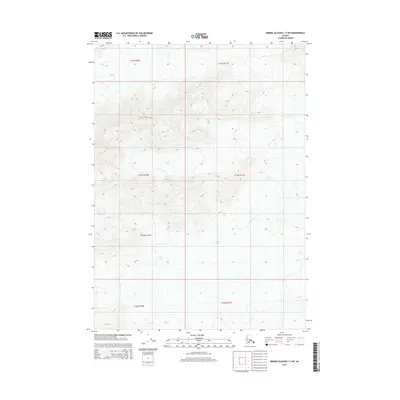
2014 Map of Bering Glacier C-7 SW
USGS Topo · Published 2014About this map
Martin River Glacier and Steller Glacier dominate this glaciated landscape in the south-central Alaskan coastal mountains. This 2014 survey captures a moment in the shifting ice geography of the region, showing the massive ice flows and the surrounding Plenisner Hills. The complex contouring reveals the movement of these glaciers across the Unorganized Borough, providing a clear picture of the ice-field boundary as it stood in the early 21st century. The map also delineates the Public Land Survey System boundaries across the ice and rock, including t15s r11e and t15s r10e. This provides an essential baseline for those studying the physical evolution of the Alaskan coast and the intersection of natural terrain with legal land divisions.
Find a feature on this map
9 named features on this map. Tap any name to fly to it.
Don’t see what you’re looking for? This feature index may not catch every label — zoom into the map to look around manually.
Map Details
Editions of this 2014 Bering Glacier C-7 SW Map
This is the sole edition of this map. No revisions or reprints were ever made.
Other maps of this area

1950 · Bering Glacier
USGS Topo · 1:250,000

1951 · Bering Glacier
USGS Topo · 1:250,000

1959 · Bering Glacier
USGS Topo · 1:250,000
1985 · Bering Glacier C-7
USGS Topo · 1:63,360
1985 · Bering Glacier B-8
USGS Topo · 1:63,360
1985 · Bering Glacier B-7
USGS Topo · 1:63,360
1985 · Bering Glacier C-8
USGS Topo · 1:63,360
2014 · Bering Glacier C-8 SE
USGS Topo · 1:25,000
2014 · Bering Glacier B-7 NW
USGS Topo · 1:25,000
2014 · Bering Glacier B-7 NE
USGS Topo · 1:25,000