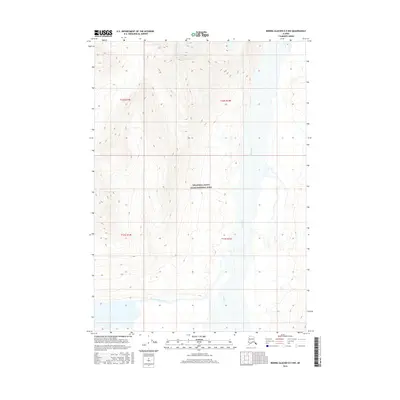
2016 Map of Bering Glacier D-5 NW
USGS Topo · Published 2016About this map
Wrangell-Saint Elias National Park encompasses the vast majority of this 2016 survey, representing a landscape defined by glacial activity and high-altitude drainage systems. The Tana River dominates the eastern and central corridors of the map, carving a wide, braided path through the valley floor. In the southwestern quadrant, the West Fork Tana River joins the primary flow, creating a complex network of active and relic river channels. The topography is marked by steep elevation changes, with numerous un-named ridges and glacial basins that feed into the Tana watershed. This document captures the primitive state of the Alaskan interior within the park boundaries, where the natural movement of the water and ice remains the primary force of change in the environment.
Find a feature on this map
7 named features on this map. Tap any name to fly to it.
Don’t see what you’re looking for? This feature index may not catch every label — zoom into the map to look around manually.
Map Details
Editions of this 2016 Bering Glacier D-5 NW Map
This is the sole edition of this map. No revisions or reprints were ever made.
Other maps of this area
1950 · Bering Glacier
USGS Topo · 1:250,000
1951 · McCarthy
USGS Topo · 1:250,000
1951 · Bering Glacier
USGS Topo · 1:250,000
1959 · McCarthy A-5
USGS Topo · 1:63,360
1959 · McCarthy A-6
USGS Topo · 1:63,360
1959 · Bering Glacier
USGS Topo · 1:250,000
1960 · McCarthy
USGS Topo · 1:250,000
1984 · Bering Glacier D-6
USGS Topo · 1:63,360
1984 · Bering Glacier D-5
USGS Topo · 1:63,360
1994 · McCarthy A-6
USGS Topo · 1:63,360