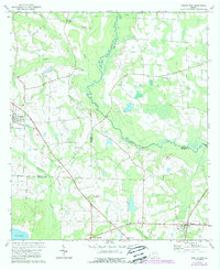
1974 Map of Berlin East
USGS Topo · Published 1988About this map
Agricultural lowlands and wetland margins define this landscape at the intersection of Colquitt, Cook, and Brooks Counties. The town of Berlin serves as a focal point in the northwest, while Barney anchors the southeast corner, connected by a network of rural roads and an extensive Old Railroad Grade that traces a diagonal path across the terrain. This corridor, passing by markers like Simpson A and Kemskey, highlights the importance of historic transport routes in shaping South Georgia's early development.
Find a feature on this map
30 named features on this map. Tap any name to fly to it.
Don’t see what you’re looking for? This feature index may not catch every label — zoom into the map to look around manually.
Map Details
Editions of this 1974 Berlin East Map
2 editions found
Other maps of this area

1953 · Waycross
USGS Topo · 1:250,000

1954 · Valdosta
USGS Topo · 1:250,000

1958 · Valdosta
USGS Topo · 1:250,000

1958 · Waycross
USGS Topo · 1:250,000

1959 · Valdosta
USGS Topo · 1:250,000

1961 · Quitman
USGS Topo · 1:62,500

1961 · Hahira West
USGS Topo · 1:24,000

1973 · Adel
USGS Topo · 1:24,000

1973 · Cecil
USGS Topo · 1:24,000

1974 · Berlin East
USGS Topo · 1:24,000