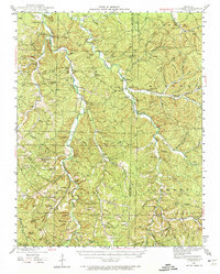
1943 Map of Berryman
USGS Topo · Published 1974About this map
The Clark National Forest provides the backdrop for this mid-century look at the eastern Ozark Highlands, where the intricate valley systems of Huzzah Creek and Courtois Creek dictate the pattern of human settlement. In this landscape, communities like Berryman and Davisville are anchored by family-named landmarks and rural institutions that reflect the era's social fabric. The presence of the Fox Theater near Davisville and the Ozark Gospel Center suggests a vibrant local culture centered around communal gathering points.
Find a feature on this map
101 named features on this map. Tap any name to fly to it.
Don’t see what you’re looking for? This feature index may not catch every label — zoom into the map to look around manually.
Map Details
Editions of this 1943 Berryman Map
4 editions found
Other maps of this area

1901 · De Soto
USGS Topo · 1:125,000

1903 · Sullivan
USGS Topo · 1:125,000

1906 · Potosi
USGS Topo · 1:62,500

1924 · Edgehill
USGS Topo · 1:62,500

1926 · Edgehill
USGS Topo · 1:62,500

1932 · Steelville
USGS Topo · 1:48,000

1933 · Steelville
USGS Topo · 1:62,500

1937 · Steelville
USGS Topo · 1:62,500

1941 · Stone Hill
USGS Topo · 1:62,500

1943 · Berryman
USGS Topo · 1:62,500