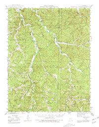
1943 Map of Berryman
USGS Topo · Published 1981About this map
Huzzah Creek and Courtois Creek wind through this corner of the Mark Twain National Forest, defining a landscape of narrow hollows and high knobs during the mid-1930s and early 1940s. The region is marked by a network of rural hubs such as Berryman, Davisville, and Westover, where local life centered around small schools like Lookout Sch and country churches including the Ozark Gospel Center. These waterways, including the East Fork Courtois Creek, carve past landmarks like the Lower Narrows and Red Bluff, illustrating the era's reliance on the natural terrain for both settlement and navigation.
Find a feature on this map
76 named features on this map. Tap any name to fly to it.
Don’t see what you’re looking for? This feature index may not catch every label — zoom into the map to look around manually.
Map Details
Editions of this 1943 Berryman Map
4 editions found
Other maps of this area

1901 · De Soto
USGS Topo · 1:125,000

1903 · Sullivan
USGS Topo · 1:125,000

1906 · Potosi
USGS Topo · 1:62,500

1924 · Edgehill
USGS Topo · 1:62,500

1926 · Edgehill
USGS Topo · 1:62,500

1932 · Steelville
USGS Topo · 1:48,000

1933 · Steelville
USGS Topo · 1:62,500

1937 · Steelville
USGS Topo · 1:62,500

1941 · Stone Hill
USGS Topo · 1:62,500

1943 · Berryman
USGS Topo · 1:62,500