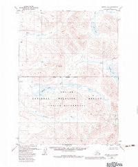
1979 Map of Bethel A-2
USGS Topo · Published 1983About this map
Togiak National Wildlife Refuge and the Togiak Wilderness dominate this Alaskan landscape, reflecting a period of significant federal land conservation following the Alaska National Interest Lands Conservation Act. The map captures a transition from the lower tundra-rich basins to the higher elevations of Crooked Mountain and the surrounding peaks. Water defines the movement through the terrain, with the Kwethluk River winding through the southern reaches and a network of drainages like Akoswift Creek and Little Swift Creek feeding into the larger hydrological system.
Find a feature on this map
14 named features on this map. Tap any name to fly to it.
Don’t see what you’re looking for? This feature index may not catch every label — zoom into the map to look around manually.
Map Details
Editions of this 1979 Bethel A-2 Map
2 editions found
Other maps of this area

1950 · Bethel
USGS Topo · 1:250,000

1951 · Goodnews
USGS Topo · 1:250,000

1954 · Bethel B-3
USGS Topo · 1:63,360

1979 · Bethel B-1
USGS Topo · 1:63,360

1979 · Bethel A-3
USGS Topo · 1:63,360

1979 · Goodnews Bay D-3
USGS Topo · 1:63,360

1979 · Bethel A-1
USGS Topo · 1:63,360

1979 · Bethel A-2
USGS Topo · 1:63,360

1979 · Goodnews Bay D-1
USGS Topo · 1:63,360

1979 · Goodnews Bay
USGS Topo · 1:250,000