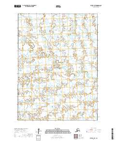
2017 Map of Bethel A-7 SE
USGS Topo · Published 2017About this map
The Middle Fork Eek River and its associated Middle Fork Eek River watershed define this area of the Bethel Census Area in southwest Alaska. This land, located within the t1s r71w, t1s r70w, t2s r71w, and t2s r70w township sections, is characterized by a dense network of wetlands and small water bodies. The absence of roads or permanent settlements in this 2017 survey reflects the preservation of the natural hydrology, which has remained largely undisturbed by industrial or residential development. It is an environment dominated by the complex flow of the Middle Fork Eek River across the tundra.
Find a feature on this map
5 named features on this map. Tap any name to fly to it.
Don’t see what you’re looking for? This feature index may not catch every label — zoom into the map to look around manually.
Map Details
Editions of this 2017 Bethel A-7 SE Map
This is the sole edition of this map. No revisions or reprints were ever made.
Other maps of this area

1950 · Bethel
USGS Topo · 1:250,000

1951 · Goodnews
USGS Topo · 1:250,000

1954 · Bethel A-7
USGS Topo · 1:63,360

1954 · Goodnews D-6
USGS Topo · 1:63,360

1954 · Goodnews D-7
USGS Topo · 1:63,360

1954 · Bethel A-6
USGS Topo · 1:63,360
1964 · Bethel A-6
USGS Topo · 1:63,360

1979 · Goodnews Bay
USGS Topo · 1:250,000

1980 · Bethel
USGS Topo · 1:250,000
2017 · Bethel A-7 SW
USGS Topo · 1:25,000