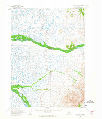
1964 Map of Bethel A-6
USGS Topo · Published 1965About this map
The Eek River meanders across this subarctic landscape, carving a prominent path through a terrain defined by extensive wetlands and complex hydrologic patterns. This 1964 survey, based on 1957 aerial photography, reveals a remote wilderness south of Bethel where the Middle Fork Eek River converges with the main stem amidst a dense network of tundra ponds and seasonal water bodies. The eastern portion of the quadrangle rises toward the prominent elevations of the Great Ridge, providing a sharp topographic contrast to the low-lying river valley. The presence of the Base Line survey marker underscores the systematic effort to map this Alaskan interior during the mid-20th century, capturing the area before any established road networks or permanent settlements were documented in this specific sector.
Find a feature on this map
4 named features on this map. Tap any name to fly to it.
Don’t see what you’re looking for? This feature index may not catch every label — zoom into the map to look around manually.
Map Details
Editions of this 1964 Bethel A-6 Map
This is the sole edition of this map. No revisions or reprints were ever made.
Other maps of this area

1950 · Bethel
USGS Topo · 1:250,000

1951 · Goodnews
USGS Topo · 1:250,000

1954 · Bethel B-6
USGS Topo · 1:63,360

1954 · Bethel B-7
USGS Topo · 1:63,360

1954 · Bethel A-5
USGS Topo · 1:63,360

1954 · Bethel B-5
USGS Topo · 1:63,360

1954 · Bethel A-7
USGS Topo · 1:63,360

1954 · Goodnews D-6
USGS Topo · 1:63,360

1954 · Goodnews D-7
USGS Topo · 1:63,360

1954 · Goodnews D-5
USGS Topo · 1:63,360