
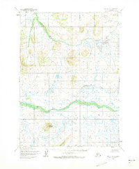
1954 Map of Bethel B-5
USGS Topo · Published 1965About this map
The Kwethluk River meanders through this Kuskokwim River delta landscape, revealing a complex hydrological network of tundra streams and seasonal wetlands. Mapped from 1957 aerial photography and field-annotated in 1954, this survey captures the interior wilderness before modern infrastructure reached the region. The glacial and alluvial history of the area is anchored by Elowaktak Mountain, a prominent landmark rising above the surrounding lowlands. Along with the Akulikutak River and Kasigluk R, these waterways represent the primary corridors for travel and traditional land use in the mid-20th century. The intricate drainage patterns of Johnson Creek and Coral Creek highlight the seasonal fluidity of this subarctic environment, offering researchers a baseline for studying geological and hydrological changes over several decades.
Find a feature on this map
6 named features on this map. Tap any name to fly to it.
Don’t see what you’re looking for? This feature index may not catch every label — zoom into the map to look around manually.
Map Details
Editions of this 1954 Bethel B-5 Map
2 editions found
Other maps of this area

1950 · Bethel
USGS Topo · 1:250,000

1954 · Bethel B-6
USGS Topo · 1:63,360

1954 · Bethel C-6
USGS Topo · 1:63,360

1954 · Bethel C-5
USGS Topo · 1:63,360

1954 · Bethel C-4
USGS Topo · 1:63,360

1954 · Bethel A-5
USGS Topo · 1:63,360

1954 · Bethel A-4
USGS Topo · 1:63,360

1954 · Bethel B-4
USGS Topo · 1:63,360

1954 · Bethel A-6
USGS Topo · 1:63,360
1964 · Bethel A-6
USGS Topo · 1:63,360