
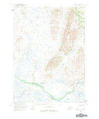
1954 Map of Bethel B-4
USGS Topo · Published 1965About this map
The Kisaralik River and Kasigluk River dominate this mid-century topographic survey of the Alaskan interior near Bethel. In this era, the landscape was documented through photogrammetric methods from aerial photographs, revealing a complex network of waterways that defined travel and subsistence in the region. The Kweth Luk River snakes through the southern portion of the quadrangle, joined by smaller tributaries like Crooked Creek and Fork Creek. The terrain is characterized by prominent high ground, including the North and South Greens, which rise above the surrounding wetlands and river valleys. This map captures the area before any established roads or trails were formally recorded, highlighting the reliance on the natural corridors of the Johnson River and Swift Creek for navigation through the vast Kuskokwim River delta surroundings.
Find a feature on this map
9 named features on this map. Tap any name to fly to it.
Don’t see what you’re looking for? This feature index may not catch every label — zoom into the map to look around manually.
Map Details
Editions of this 1954 Bethel B-4 Map
2 editions found
Other maps of this area

1950 · Bethel
USGS Topo · 1:250,000

1954 · Bethel C-5
USGS Topo · 1:63,360

1954 · Bethel C-4
USGS Topo · 1:63,360

1954 · Bethel C-3
USGS Topo · 1:63,360

1954 · Bethel A-5
USGS Topo · 1:63,360

1954 · Bethel A-4
USGS Topo · 1:63,360

1954 · Bethel B-3
USGS Topo · 1:63,360

1954 · Bethel B-5
USGS Topo · 1:63,360

1979 · Bethel A-3
USGS Topo · 1:63,360

1980 · Bethel
USGS Topo · 1:250,000