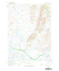
1954 Map of Bethel B-4
USGS Topo · Published 1983About this map
Greenstone Ridge dominates this interior Alaskan landscape, serving as a prominent north-south backbone between several major river systems. The Kisaralik River flows through the northeast corner, while the southern reaches are defined by the broad, braided course of the Kwethluk River. The map reveals a complex hydrologic network where smaller tributaries like Crooked Creek and Fork Creek meet the larger glacial-fed streams. Based on 1957 aerial photography and 1954 field annotations, the topography captures a remote region devoid of permanent roads or settlements during the mid-century era. The intricate drainage patterns of Johnson Creek and Kasigluk River reflect the seasonal movement of water across the Seward Meridian land lines, which remained unsurveyed and unmarked at the time of this survey.
Find a feature on this map
8 named features on this map. Tap any name to fly to it.
Don’t see what you’re looking for? This feature index may not catch every label — zoom into the map to look around manually.
Map Details
Editions of this 1954 Bethel B-4 Map
2 editions found
Other maps of this area

1950 · Bethel
USGS Topo · 1:250,000

1954 · Bethel C-5
USGS Topo · 1:63,360

1954 · Bethel C-4
USGS Topo · 1:63,360

1954 · Bethel C-3
USGS Topo · 1:63,360

1954 · Bethel A-5
USGS Topo · 1:63,360

1954 · Bethel A-4
USGS Topo · 1:63,360

1954 · Bethel B-3
USGS Topo · 1:63,360

1954 · Bethel B-4
USGS Topo · 1:63,360

1954 · Bethel B-5
USGS Topo · 1:63,360

1979 · Bethel A-3
USGS Topo · 1:63,360