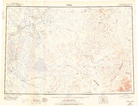
1950 Map of Bethel
USGS Topo · Published 1950About this map
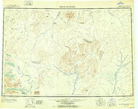
The Kuskokwim River serves as the primary artery for life and commerce in this mid-century portrait of southwestern Alaska, connecting riverside settlements like Bethel, Akiachak, and Akiak. While Bethel operates as a regional hub with its Landing Field, a network of trails and waterways extends eastward toward the formidable Kilbuck Mountains. The map documents the region's resource-based economy, specifically noting the Marvel Creek Field and Granite Creek Field, which suggest active mining or exploration near Marvel Dome.
Find a feature on this map
50 named features on this map. Tap any name to fly to it.
Don’t see what you’re looking for? This feature index may not catch every label — zoom into the map to look around manually.
Map Details
Editions of this 1950 Bethel Map
3 editions found
Other maps of this area
1947 · Russian Mission
USGS Topo · 1:250,000

1950 · Russian Mission
USGS Topo · 1:250,000
1950 · Sleetmute
USGS Topo · 1:250,000

1950 · Bethel
USGS Topo · 1:250,000

1950 · Taylor Mountains
USGS Topo · 1:250,000

1951 · Marshall
USGS Topo · 1:250,000
1951 · Taylor Mountains
USGS Topo · 1:250,000

1951 · Kuskokwim Bay
USGS Topo · 1:250,000

1951 · Dillingham
USGS Topo · 1:250,000

1951 · Goodnews
USGS Topo · 1:250,000