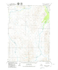
1979 Map of Bethel C-1
USGS Topo · Published 1979About this map
The Aniak River and Kipchuk River systems dominate this interior Alaskan landscape, providing a detailed look at the drainage patterns of the Kuskokwim River watershed during the late 1970s. This survey records a wilderness environment devoid of permanent roads or settlements, where the terrain is defined by isolated peaks such as Gemuk Mtn, Cone, Cap, and the distinctively named Obvious. The eastern portion of the map covers a section of Wood-Tikchik State Park, illustrating the boundary of this protected area before major modern recreational development. For those studying the geography of southwestern Alaska, the map preserves the exact positions of USGS benchmarks and local landmarks used by bush pilots and early researchers in this roadless territory.
Find a feature on this map
7 named features on this map. Tap any name to fly to it.
Don’t see what you’re looking for? This feature index may not catch every label — zoom into the map to look around manually.
Map Details
Editions of this 1979 Bethel C-1 Map
2 editions found
Other maps of this area

1950 · Bethel
USGS Topo · 1:250,000

1950 · Taylor Mountains
USGS Topo · 1:250,000

1951 · Taylor Mountains
USGS Topo · 1:250,000

1954 · Taylor Mountains
USGS Topo · 1:250,000

1954 · Taylor Mountains D-8
USGS Topo · 1:63,360

1954 · Taylor Mountains B-8
USGS Topo · 1:63,360

1954 · Taylor Mountains C-8
USGS Topo · 1:63,360

1979 · Bethel D-2
USGS Topo · 1:63,360

1979 · Bethel B-1
USGS Topo · 1:63,360
1979 · Bethel D-1
USGS Topo · 1:63,360