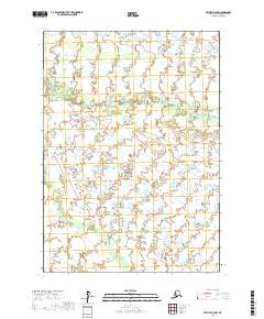
2017 Map of Bethel D-4 NW
USGS Topo · Published 2017About this map
The Tuluksak River winds across this Alaskan landscape, defining the northern and central reaches of the Bethel Census Area in the late 2010s. This survey, conducted by the U.S. Geological Survey, illustrates a vast network of water bodies and wetlands characteristic of the region's low-lying terrain. The drainage systems of Otter Cr and the Fog River dominate the southern half of the map, revealing the intricate hydrological patterns of the tundra. The absence of roads or permanent settlements within these townships emphasizes the wilderness character of the territory during this period of the twenty-first century. These watercourses serve as the primary geographic landmarks, providing essential context for researchers and land managers documenting the environmental history of the Kuskokwim River drainage basin.
Find a feature on this map
9 named features on this map. Tap any name to fly to it.
Don’t see what you’re looking for? This feature index may not catch every label — zoom into the map to look around manually.
Map Details
Editions of this 2017 Bethel D-4 NW Map
This is the sole edition of this map. No revisions or reprints were ever made.
Other maps of this area

1947 · Russian Mission
USGS Topo · 1:250,000

1950 · Russian Mission
USGS Topo · 1:250,000

1950 · Bethel
USGS Topo · 1:250,000

1954 · Russian Mission A-4
USGS Topo · 1:63,360

1954 · Russian Mission A-5
USGS Topo · 1:63,360

1954 · Bethel D-4
USGS Topo · 1:63,360

1954 · Bethel D-5
USGS Topo · 1:63,360

1980 · Russian Mission
USGS Topo · 1:250,000

1980 · Bethel
USGS Topo · 1:250,000
2017 · Russian Mission A-4 SE
USGS Topo · 1:25,000