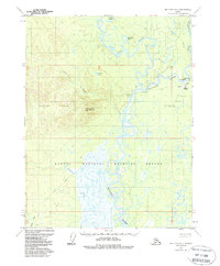
1970 Map of Bettles D-4
USGS Topo · Published 1988About this map
Evansville serves as the primary hub in this interior Alaskan landscape, situated where the Wild River meets the sweeping curves of the Koyukuk River. The settlement is supported by vital transportation infrastructure of the era, including the Bettles Airport, a Boat and Seaplane Base, and a series of Radio Towers. To the west, the Alatna Hills rise toward Lookout Mountain, while the southern portion of the map is dominated by the wetlands of the Kanuti National Wildlife Refuge. Grounded in a 1970 survey with minor revisions in 1988, the map documents a reliance on seasonal transport, notably the Winter Trail that weaves across the river valleys. Local heritage is marked by the Bettles Cem and scattered Cabin sites, illustrating the thin but persistent footprint of human activity along the John River corridor.
Find a feature on this map
28 named features on this map. Tap any name to fly to it.
Don’t see what you’re looking for? This feature index may not catch every label — zoom into the map to look around manually.
Map Details
Editions of this 1970 Bettles D-4 Map
2 editions found
Other maps of this area

1951 · Bettles
USGS Topo · 1:250,000

1951 · Wiseman
USGS Topo · 1:250,000

1956 · Bettles
USGS Topo · 1:250,000

1956 · Wiseman
USGS Topo · 1:250,000

1964 · Wiseman
USGS Topo · 1:250,000

1970 · Bettles D-4
USGS Topo · 1:63,360

1970 · Wiseman A-4
USGS Topo · 1:63,360

1970 · Bettles C-4
USGS Topo · 1:63,360

1970 · Wiseman A-3
USGS Topo · 1:63,360
1970 · Bettles C-5
USGS Topo · 1:63,360