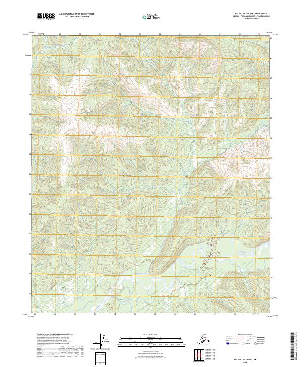
2024 Map of Big Delta C-4 NW
USGS Topo · Published 2024About this map
Marshall Mountain anchors the central topography of this Interior Alaska region, where the drainage systems of the Tanana and Chena watersheds meet. The southern portion of the map is defined by the winding course of the Salcha River, which receives the waters of Deep Creek as it flows through the low-lying wetlands. To the north, the headwaters of the South Fork Chena River cut through higher elevations, illustrating the complex hydrology that governs this subarctic landscape. The map provides a precise view of the Public Land Survey System grid, including boundaries for t2s r9e and t3s r10e, which are essential for identifying land tracts in this predominantly roadless wilderness. This contemporary survey preserves the traditional names of the interior's waterways and peaks, offering a baseline for environmental and geological study in the Fairbanks North Star Borough.
Find a feature on this map
9 named features on this map. Tap any name to fly to it.
Don’t see what you’re looking for? This feature index may not catch every label — zoom into the map to look around manually.
Map Details
Editions of this 2024 Big Delta C-4 NW Map
This is the sole edition of this map. No revisions or reprints were ever made.
Other maps of this area

1950 · Big Delta
USGS Topo · 1:250,000

1951 · Big Delta
USGS Topo · 1:250,000

1958 · Big Delta C-5
USGS Topo · 1:63,360

1958 · Big Delta D-5
USGS Topo · 1:63,360

1958 · Big Delta C-4
USGS Topo · 1:63,360

1958 · Big Delta D-4
USGS Topo · 1:63,360

1958 · Big Delta
USGS Topo · 1:250,000
2016 · Big Delta D-4 SE
USGS Topo · 1:25,000
2016 · Big Delta C-4 SW
USGS Topo · 1:25,000
2016 · Big Delta C-5 NE
USGS Topo · 1:25,000