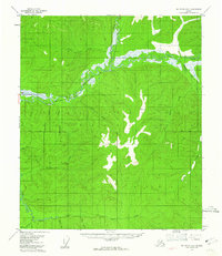
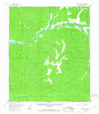
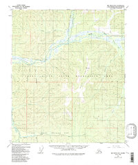
1958 Map of Big Delta D-5
USGS Topo · Published 1961About this map
The North Fork Chena River and Chena River systems dominate this interior Alaska landscape, captured during a period of infrastructure expansion in the late 1950s. A section of road marked as Under Construction pushes into the drainage near Rock Creek, signaling the transition from seasonal Tractor Trail access to more permanent routes. Historical human presence is sparsely marked by a Cabin and multiple Cabins, indicating the remote nature of the region.
Find a feature on this map
22 named features on this map. Tap any name to fly to it.
Don’t see what you’re looking for? This feature index may not catch every label — zoom into the map to look around manually.
Map Details
Editions of this 1958 Big Delta D-5 Map
4 editions found
Historical Maps of Fairbanks North Star Through Time
340 maps found

1949 Big Delta B-5
Fairbanks North Star Borough, AK

1949 Big Delta B-6
Fairbanks North Star Borough, AK

1949 Big Delta C-6
Fairbanks North Star Borough, AK

1949 Fairbanks C-1
Fairbanks North Star Borough, AK

1949 Fairbanks C-2
Fairbanks North Star Borough, AK

1949 Fairbanks D-1
Fairbanks North Star Borough, AK

1949 Fairbanks D-2
Fairbanks North Star Borough, AK

1949 Fairbanks D-3
Fairbanks North Star Borough, AK

1950 Big Delta D-6
Fairbanks North Star Borough, AK

1950 Fairbanks B-1
Fairbanks North Star Borough, AK

1950 Fairbanks B-2
Fairbanks North Star Borough, AK

1950 Fairbanks C-1
Fairbanks North Star Borough, AK

1950 Fairbanks C-3
Fairbanks North Star Borough, AK

1950 Fairbanks D-3
Fairbanks North Star Borough, AK

1951 Circle A-5
Fairbanks North Star Borough, AK

1951 Fairbanks B-1
Fairbanks North Star Borough, AK

1951 Fairbanks B-2
Fairbanks North Star Borough, AK

1952 Big Delta B-5
Fairbanks North Star Borough, AK

1952 Big Delta B-6
Fairbanks North Star Borough, AK

1952 Big Delta C-6
Fairbanks North Star Borough, AK

1952 Big Delta D-6
Fairbanks North Star Borough, AK

1952 Circle A-4
Fairbanks North Star Borough, AK

1952 Circle A-5
Fairbanks North Star Borough, AK

1952 Fairbanks C-1
Fairbanks North Star Borough, AK

1952 Fairbanks C-2
Fairbanks North Star Borough, AK

1952 Fairbanks C-3
Fairbanks North Star Borough, AK

1952 Fairbanks D-1
Fairbanks North Star Borough, AK

1952 Fairbanks D-2
Fairbanks North Star Borough, AK

1952 Fairbanks D-3
Fairbanks North Star Borough, AK

1952 Livengood A-1
Fairbanks North Star Borough, AK

1952 Livengood A-2
Fairbanks North Star Borough, AK

1953 Livengood A-3
Fairbanks North Star Borough, AK

1954 Circle A-5
Fairbanks North Star Borough, AK

1954 Circle A-6
Fairbanks North Star Borough, AK

1954 Circle B-5
Fairbanks North Star Borough, AK

1954 Fairbanks D-2
Fairbanks North Star Borough, AK

1954 Livengood A-1
Fairbanks North Star Borough, AK

1954 Livengood A-2
Fairbanks North Star Borough, AK

1955 Fairbanks D-2
Fairbanks North Star Borough, AK

1958 Big Delta C-2
Fairbanks North Star Borough, AK

1958 Big Delta C-3
Fairbanks North Star Borough, AK

1958 Big Delta C-4
Fairbanks North Star Borough, AK

1958 Big Delta C-5
Fairbanks North Star Borough, AK

1958 Big Delta D-1
Fairbanks North Star Borough, AK

1958 Big Delta D-2
Fairbanks North Star Borough, AK

1958 Big Delta D-3
Fairbanks North Star Borough, AK

1958 Big Delta D-4
Fairbanks North Star Borough, AK

1958 Big Delta D-5
Fairbanks North Star Borough, AK

1965 Fairbanks D-2
Fairbanks North Star Borough, AK

1966 Fairbanks D-1 SW
Fairbanks North Star Borough, AK

1966 Fairbanks D-2 NE
Fairbanks North Star Borough, AK

1966 Fairbanks D-2 NW
Fairbanks North Star Borough, AK

1966 Fairbanks D-2 SE
Fairbanks North Star Borough, AK

1966 Fairbanks D-2 SW
Fairbanks North Star Borough, AK

1973 Big Delta D-3
Fairbanks North Star Borough, AK

1992 Big Delta B-6 NW
Fairbanks North Star Borough, AK

1992 Big Delta C-6 NW
Fairbanks North Star Borough, AK

1992 Big Delta C-6 SW
Fairbanks North Star Borough, AK

1992 Big Delta D-6 NW
Fairbanks North Star Borough, AK

1992 Big Delta D-6 SW
Fairbanks North Star Borough, AK

1992 Fairbanks C-1 NE
Fairbanks North Star Borough, AK

1992 Fairbanks C-1 NW
Fairbanks North Star Borough, AK

1992 Fairbanks C-1 SE
Fairbanks North Star Borough, AK

1992 Fairbanks D-1 NE
Fairbanks North Star Borough, AK

1992 Fairbanks D-1 NW
Fairbanks North Star Borough, AK

1992 Fairbanks D-1 SE
Fairbanks North Star Borough, AK

1992 Fairbanks D-1 SW
Fairbanks North Star Borough, AK

1992 Fairbanks D-2 NE
Fairbanks North Star Borough, AK

1992 Fairbanks D-2 NW
Fairbanks North Star Borough, AK

1992 Fairbanks D-2 SE
Fairbanks North Star Borough, AK

1992 Fairbanks D-2 SW
Fairbanks North Star Borough, AK

1992 Fairbanks D-3 NE
Fairbanks North Star Borough, AK

1992 Fairbanks D-3 SE
Fairbanks North Star Borough, AK

1992 Fairbanks D-3 SW
Fairbanks North Star Borough, AK

1992 Livengood A-1 SE
Fairbanks North Star Borough, AK

1992 Livengood A-1 SW
Fairbanks North Star Borough, AK

1992 Livengood A-2 SE
Fairbanks North Star Borough, AK

2013 Big Delta B-6 NW
Fairbanks North Star Borough, AK

2013 Big Delta B-6 SW
Fairbanks North Star Borough, AK

2013 Fairbanks B-1 NE
Fairbanks North Star Borough, AK

2013 Fairbanks B-1 NW
Fairbanks North Star Borough, AK

2013 Fairbanks B-1 SE
Fairbanks North Star Borough, AK

2013 Fairbanks B-1 SW
Fairbanks North Star Borough, AK

2013 Fairbanks B-2 NE
Fairbanks North Star Borough, AK

2013 Fairbanks B-2 NW
Fairbanks North Star Borough, AK

2013 Fairbanks B-2 SE
Fairbanks North Star Borough, AK

2013 Fairbanks B-2 SW
Fairbanks North Star Borough, AK

2013 Fairbanks B-3 NE
Fairbanks North Star Borough, AK

2013 Fairbanks C-2 NE
Fairbanks North Star Borough, AK

2013 Fairbanks C-2 NW
Fairbanks North Star Borough, AK

2013 Fairbanks C-2 SE
Fairbanks North Star Borough, AK

2013 Fairbanks C-2 SW
Fairbanks North Star Borough, AK

2013 Fairbanks C-3 NE
Fairbanks North Star Borough, AK

2013 Fairbanks C-3 NW
Fairbanks North Star Borough, AK

2013 Fairbanks C-3 SE
Fairbanks North Star Borough, AK

2013 Fairbanks C-3 SW
Fairbanks North Star Borough, AK

2013 Fairbanks D-2 NW
Fairbanks North Star Borough, AK

2013 Fairbanks D-2 SW
Fairbanks North Star Borough, AK

2013 Fairbanks D-3 NE
Fairbanks North Star Borough, AK

2013 Fairbanks D-3 NW
Fairbanks North Star Borough, AK

2013 Fairbanks D-3 SE
Fairbanks North Star Borough, AK

2013 Fairbanks D-3 SW
Fairbanks North Star Borough, AK

2016 Big Delta B-5 NE
Fairbanks North Star Borough, AK

2016 Big Delta B-5 NW
Fairbanks North Star Borough, AK

2016 Big Delta B-5 SW
Fairbanks North Star Borough, AK

2016 Big Delta B-6 NE
Fairbanks North Star Borough, AK

2016 Big Delta B-6 SE
Fairbanks North Star Borough, AK

2016 Big Delta C-3 NE
Fairbanks North Star Borough, AK

2016 Big Delta C-3 NW
Fairbanks North Star Borough, AK

2016 Big Delta C-3 SE
Fairbanks North Star Borough, AK

2016 Big Delta C-3 SW
Fairbanks North Star Borough, AK

2016 Big Delta C-4 NE
Fairbanks North Star Borough, AK

2016 Big Delta C-4 NW
Fairbanks North Star Borough, AK

2016 Big Delta C-4 SE
Fairbanks North Star Borough, AK

2016 Big Delta C-4 SW
Fairbanks North Star Borough, AK

2016 Big Delta C-5 NE
Fairbanks North Star Borough, AK

2016 Big Delta C-5 NW
Fairbanks North Star Borough, AK

2016 Big Delta C-5 SE
Fairbanks North Star Borough, AK

2016 Big Delta C-5 SW
Fairbanks North Star Borough, AK

2016 Big Delta C-6 NE
Fairbanks North Star Borough, AK

2016 Big Delta C-6 NW
Fairbanks North Star Borough, AK

2016 Big Delta C-6 SE
Fairbanks North Star Borough, AK

2016 Big Delta C-6 SW
Fairbanks North Star Borough, AK

2016 Big Delta D-3 NE
Fairbanks North Star Borough, AK

2016 Big Delta D-3 NW
Fairbanks North Star Borough, AK

2016 Big Delta D-3 SE
Fairbanks North Star Borough, AK

2016 Big Delta D-3 SW
Fairbanks North Star Borough, AK

2016 Big Delta D-4 NE
Fairbanks North Star Borough, AK

2016 Big Delta D-4 NW
Fairbanks North Star Borough, AK

2016 Big Delta D-4 SE
Fairbanks North Star Borough, AK

2016 Big Delta D-4 SW
Fairbanks North Star Borough, AK

2016 Big Delta D-5 NE
Fairbanks North Star Borough, AK

2016 Big Delta D-5 NW
Fairbanks North Star Borough, AK

2016 Big Delta D-5 SE
Fairbanks North Star Borough, AK

2016 Big Delta D-5 SW
Fairbanks North Star Borough, AK

2016 Big Delta D-6 NE
Fairbanks North Star Borough, AK

2016 Big Delta D-6 NW
Fairbanks North Star Borough, AK

2016 Big Delta D-6 SE
Fairbanks North Star Borough, AK

2016 Big Delta D-6 SW
Fairbanks North Star Borough, AK

2016 Fairbanks C-1 NE
Fairbanks North Star Borough, AK

2016 Fairbanks C-1 NW
Fairbanks North Star Borough, AK

2016 Fairbanks C-1 SE
Fairbanks North Star Borough, AK

2016 Fairbanks C-1 SW
Fairbanks North Star Borough, AK

2016 Fairbanks D-1 NE
Fairbanks North Star Borough, AK

2016 Fairbanks D-1 NW
Fairbanks North Star Borough, AK

2016 Fairbanks D-1 SE
Fairbanks North Star Borough, AK

2016 Fairbanks D-1 SW
Fairbanks North Star Borough, AK

2017 Chandalar A-1 SW
Fairbanks North Star Borough, AK

2017 Fairbanks D-2 NE
Fairbanks North Star Borough, AK

2017 Fairbanks D-2 SE
Fairbanks North Star Borough, AK

2017 Livengood A-1 NE
Fairbanks North Star Borough, AK

2017 Livengood A-1 NW
Fairbanks North Star Borough, AK

2017 Livengood A-1 SW
Fairbanks North Star Borough, AK

2017 Livengood A-2 NE
Fairbanks North Star Borough, AK

2017 Livengood A-2 NW
Fairbanks North Star Borough, AK

2017 Livengood A-2 SE
Fairbanks North Star Borough, AK

2017 Livengood A-2 SW
Fairbanks North Star Borough, AK

2017 Livengood A-3 NE
Fairbanks North Star Borough, AK

2017 Livengood A-3 NW
Fairbanks North Star Borough, AK

2017 Livengood A-3 SE
Fairbanks North Star Borough, AK

2017 Livengood A-3 SW
Fairbanks North Star Borough, AK

2017 Livengood A-4 NE
Fairbanks North Star Borough, AK

2017 Livengood A-4 SE
Fairbanks North Star Borough, AK

2018 Big Delta C-1 NE
Fairbanks North Star Borough, AK

2018 Big Delta C-1 NW
Fairbanks North Star Borough, AK

2018 Big Delta C-2 NE
Fairbanks North Star Borough, AK

2018 Big Delta C-2 NW
Fairbanks North Star Borough, AK

2018 Big Delta D-1 NE
Fairbanks North Star Borough, AK

2018 Big Delta D-1 NW
Fairbanks North Star Borough, AK

2018 Big Delta D-1 SE
Fairbanks North Star Borough, AK

2018 Big Delta D-1 SW
Fairbanks North Star Borough, AK

2018 Big Delta D-2 NE
Fairbanks North Star Borough, AK

2018 Big Delta D-2 NW
Fairbanks North Star Borough, AK

2018 Big Delta D-2 SE
Fairbanks North Star Borough, AK

2018 Big Delta D-2 SW
Fairbanks North Star Borough, AK

2018 Charley River A-6 SW
Fairbanks North Star Borough, AK

2018 Circle A-1 SE
Fairbanks North Star Borough, AK

2018 Circle A-1 SW
Fairbanks North Star Borough, AK

2018 Circle A-2 SE
Fairbanks North Star Borough, AK

2018 Circle A-2 SW
Fairbanks North Star Borough, AK

2018 Circle A-3 SE
Fairbanks North Star Borough, AK

2018 Circle A-3 SW
Fairbanks North Star Borough, AK

2018 Circle A-4 NW
Fairbanks North Star Borough, AK

2018 Circle A-4 SW
Fairbanks North Star Borough, AK

2018 Circle A-5 NE
Fairbanks North Star Borough, AK

2018 Circle A-5 NW
Fairbanks North Star Borough, AK

2018 Circle A-5 SE
Fairbanks North Star Borough, AK

2018 Circle A-5 SW
Fairbanks North Star Borough, AK

2018 Circle A-6 NE
Fairbanks North Star Borough, AK

2018 Circle A-6 NW
Fairbanks North Star Borough, AK

2018 Circle A-6 SE
Fairbanks North Star Borough, AK

2018 Circle A-6 SW
Fairbanks North Star Borough, AK

2018 Circle B-5 NW
Fairbanks North Star Borough, AK

2018 Circle B-5 SW
Fairbanks North Star Borough, AK

2018 Circle B-6 NE
Fairbanks North Star Borough, AK

2018 Circle B-6 SE
Fairbanks North Star Borough, AK

2018 Livengood A-1 SE
Fairbanks North Star Borough, AK

2021 Big Delta B-5 SW
Fairbanks North Star Borough, AK

2021 Big Delta B-6 NE
Fairbanks North Star Borough, AK

2021 Big Delta B-6 NW
Fairbanks North Star Borough, AK

2021 Big Delta B-6 SE
Fairbanks North Star Borough, AK

2021 Big Delta B-6 SW
Fairbanks North Star Borough, AK

2021 Big Delta C-4 NE
Fairbanks North Star Borough, AK

2021 Big Delta C-4 NW
Fairbanks North Star Borough, AK

2021 Big Delta C-5 SE
Fairbanks North Star Borough, AK

2021 Big Delta C-5 SW
Fairbanks North Star Borough, AK

2021 Big Delta C-6 NW
Fairbanks North Star Borough, AK

2021 Big Delta C-6 SE
Fairbanks North Star Borough, AK

2021 Big Delta C-6 SW
Fairbanks North Star Borough, AK

2021 Big Delta D-5 NE
Fairbanks North Star Borough, AK

2021 Big Delta D-5 NW
Fairbanks North Star Borough, AK

2021 Big Delta D-6 NE
Fairbanks North Star Borough, AK

2021 Big Delta D-6 NW
Fairbanks North Star Borough, AK

2021 Big Delta D-6 SE
Fairbanks North Star Borough, AK

2021 Big Delta D-6 SW
Fairbanks North Star Borough, AK

2021 Circle A-5 SE
Fairbanks North Star Borough, AK

2021 Fairbanks B-1 NE
Fairbanks North Star Borough, AK

2021 Fairbanks C-1 NE
Fairbanks North Star Borough, AK

2021 Fairbanks C-1 NW
Fairbanks North Star Borough, AK

2021 Fairbanks C-1 SE
Fairbanks North Star Borough, AK

2021 Fairbanks C-3 NE
Fairbanks North Star Borough, AK

2021 Fairbanks C-3 NW
Fairbanks North Star Borough, AK

2021 Fairbanks D-1 NE
Fairbanks North Star Borough, AK

2021 Fairbanks D-1 NW
Fairbanks North Star Borough, AK

2021 Fairbanks D-1 SE
Fairbanks North Star Borough, AK

2021 Fairbanks D-1 SW
Fairbanks North Star Borough, AK

2021 Fairbanks D-2 NE
Fairbanks North Star Borough, AK

2021 Fairbanks D-2 NW
Fairbanks North Star Borough, AK

2021 Fairbanks D-2 SE
Fairbanks North Star Borough, AK

2021 Fairbanks D-2 SW
Fairbanks North Star Borough, AK

2021 Fairbanks D-3 NE
Fairbanks North Star Borough, AK

2021 Fairbanks D-3 NW
Fairbanks North Star Borough, AK

2021 Fairbanks D-3 SE
Fairbanks North Star Borough, AK

2021 Fairbanks D-3 SW
Fairbanks North Star Borough, AK

2021 Livengood A-1 NE
Fairbanks North Star Borough, AK

2021 Livengood A-1 NW
Fairbanks North Star Borough, AK

2021 Livengood A-1 SE
Fairbanks North Star Borough, AK

2021 Livengood A-1 SW
Fairbanks North Star Borough, AK

2021 Livengood A-2 NE
Fairbanks North Star Borough, AK

2021 Livengood A-2 NW
Fairbanks North Star Borough, AK

2021 Livengood A-2 SE
Fairbanks North Star Borough, AK

2021 Livengood A-2 SW
Fairbanks North Star Borough, AK

2021 Livengood A-3 NE
Fairbanks North Star Borough, AK

2021 Livengood A-3 SE
Fairbanks North Star Borough, AK

2021 Livengood A-3 SW
Fairbanks North Star Borough, AK

2024 Big Delta B-5 NE
Fairbanks North Star Borough, AK

2024 Big Delta B-5 NW
Fairbanks North Star Borough, AK

2024 Big Delta B-5 SW
Fairbanks North Star Borough, AK

2024 Big Delta B-6 NE
Fairbanks North Star Borough, AK

2024 Big Delta B-6 SE
Fairbanks North Star Borough, AK

2024 Big Delta C-1 NE
Fairbanks North Star Borough, AK

2024 Big Delta C-1 NW
Fairbanks North Star Borough, AK

2024 Big Delta C-2 NE
Fairbanks North Star Borough, AK

2024 Big Delta C-2 NW
Fairbanks North Star Borough, AK

2024 Big Delta C-3 NE
Fairbanks North Star Borough, AK

2024 Big Delta C-3 NW
Fairbanks North Star Borough, AK

2024 Big Delta C-3 SE
Fairbanks North Star Borough, AK

2024 Big Delta C-3 SW
Fairbanks North Star Borough, AK

2024 Big Delta C-4 NE
Fairbanks North Star Borough, AK

2024 Big Delta C-4 NW
Fairbanks North Star Borough, AK

2024 Big Delta C-4 SE
Fairbanks North Star Borough, AK

2024 Big Delta C-4 SW
Fairbanks North Star Borough, AK

2024 Big Delta C-5 NE
Fairbanks North Star Borough, AK

2024 Big Delta C-5 NW
Fairbanks North Star Borough, AK

2024 Big Delta C-5 SE
Fairbanks North Star Borough, AK

2024 Big Delta C-5 SW
Fairbanks North Star Borough, AK

2024 Big Delta C-6 NE
Fairbanks North Star Borough, AK

2024 Big Delta C-6 NW
Fairbanks North Star Borough, AK

2024 Big Delta C-6 SE
Fairbanks North Star Borough, AK

2024 Big Delta D-1 NE
Fairbanks North Star Borough, AK

2024 Big Delta D-1 NW
Fairbanks North Star Borough, AK

2024 Big Delta D-1 SE
Fairbanks North Star Borough, AK

2024 Big Delta D-1 SW
Fairbanks North Star Borough, AK

2024 Big Delta D-2 NE
Fairbanks North Star Borough, AK

2024 Big Delta D-2 NW
Fairbanks North Star Borough, AK

2024 Big Delta D-2 SE
Fairbanks North Star Borough, AK

2024 Big Delta D-2 SW
Fairbanks North Star Borough, AK

2024 Big Delta D-3 NE
Fairbanks North Star Borough, AK

2024 Big Delta D-3 NW
Fairbanks North Star Borough, AK

2024 Big Delta D-3 SE
Fairbanks North Star Borough, AK

2024 Big Delta D-3 SW
Fairbanks North Star Borough, AK

2024 Big Delta D-4 NE
Fairbanks North Star Borough, AK

2024 Big Delta D-4 NW
Fairbanks North Star Borough, AK

2024 Big Delta D-4 SE
Fairbanks North Star Borough, AK

2024 Big Delta D-4 SW
Fairbanks North Star Borough, AK

2024 Big Delta D-5 NE
Fairbanks North Star Borough, AK

2024 Big Delta D-5 NW
Fairbanks North Star Borough, AK

2024 Big Delta D-5 SE
Fairbanks North Star Borough, AK

2024 Big Delta D-5 SW
Fairbanks North Star Borough, AK

2024 Big Delta D-6 NE
Fairbanks North Star Borough, AK

2024 Big Delta D-6 NW
Fairbanks North Star Borough, AK

2024 Big Delta D-6 SE
Fairbanks North Star Borough, AK

2024 Big Delta D-6 SW
Fairbanks North Star Borough, AK

2024 Circle A-1 SE
Fairbanks North Star Borough, AK

2024 Circle A-1 SW
Fairbanks North Star Borough, AK

2024 Circle A-2 SE
Fairbanks North Star Borough, AK

2024 Circle A-2 SW
Fairbanks North Star Borough, AK

2024 Circle A-3 SE
Fairbanks North Star Borough, AK

2024 Circle A-3 SW
Fairbanks North Star Borough, AK

2024 Circle A-4 NW
Fairbanks North Star Borough, AK

2024 Circle A-4 SW
Fairbanks North Star Borough, AK

2024 Circle A-5 NE
Fairbanks North Star Borough, AK

2024 Circle A-5 NW
Fairbanks North Star Borough, AK

2024 Circle A-5 SE
Fairbanks North Star Borough, AK

2024 Circle A-5 SW
Fairbanks North Star Borough, AK

2024 Circle A-6 NE
Fairbanks North Star Borough, AK

2024 Circle A-6 NW
Fairbanks North Star Borough, AK

2024 Circle A-6 SE
Fairbanks North Star Borough, AK

2024 Circle A-6 SW
Fairbanks North Star Borough, AK

2024 Circle B-5 NW
Fairbanks North Star Borough, AK

2024 Circle B-5 SW
Fairbanks North Star Borough, AK

2024 Circle B-6 NE
Fairbanks North Star Borough, AK

2024 Circle B-6 SE
Fairbanks North Star Borough, AK

2024 Fairbanks C-3 NW
Fairbanks North Star Borough, AK

2024 Fairbanks D-1 NE
Fairbanks North Star Borough, AK

2024 Fairbanks D-1 NW
Fairbanks North Star Borough, AK

2024 Fairbanks D-1 SE
Fairbanks North Star Borough, AK

2024 Fairbanks D-1 SW
Fairbanks North Star Borough, AK

2024 Fairbanks D-2 NE
Fairbanks North Star Borough, AK

2024 Fairbanks D-2 NW
Fairbanks North Star Borough, AK

2024 Fairbanks D-2 SE
Fairbanks North Star Borough, AK

2024 Fairbanks D-2 SW
Fairbanks North Star Borough, AK

2024 Fairbanks D-3 NE
Fairbanks North Star Borough, AK

2024 Fairbanks D-3 NW
Fairbanks North Star Borough, AK

2024 Fairbanks D-3 SE
Fairbanks North Star Borough, AK

2024 Fairbanks D-3 SW
Fairbanks North Star Borough, AK

2024 Livengood A-1 NE
Fairbanks North Star Borough, AK

2024 Livengood A-1 NW
Fairbanks North Star Borough, AK

2024 Livengood A-1 SE
Fairbanks North Star Borough, AK

2024 Livengood A-1 SW
Fairbanks North Star Borough, AK

2024 Livengood A-2 NE
Fairbanks North Star Borough, AK

2024 Livengood A-2 NW
Fairbanks North Star Borough, AK

2024 Livengood A-2 SE
Fairbanks North Star Borough, AK

2024 Livengood A-2 SW
Fairbanks North Star Borough, AK

2024 Livengood A-3 NE
Fairbanks North Star Borough, AK

2024 Livengood A-3 NW
Fairbanks North Star Borough, AK

2024 Livengood A-3 SE
Fairbanks North Star Borough, AK

2024 Livengood A-3 SW
Fairbanks North Star Borough, AK

2024 Livengood A-4 NE
Fairbanks North Star Borough, AK

2024 Livengood A-4 SE
Fairbanks North Star Borough, AK