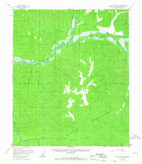
1958 Map of Big Delta D-5
USGS Topo · Published 1967About this map
The Chena River and its major tributaries, including the East Fork Chena River and South Fork Chena River, define the geography of this Interior Alaska region. Mapped during the late 1950s with minor revisions in the 1960s, the landscape is marked by the presence of a large Military Reservation and the distinctive geological formation known as Granite Tors. Remote outposts such as Globe and scattered cabins hint at the seasonal habitation and resource activity typical of the Fairbanks North Star Borough during this era.
Find a feature on this map
27 named features on this map. Tap any name to fly to it.
Don’t see what you’re looking for? This feature index may not catch every label — zoom into the map to look around manually.
Map Details
Editions of this 1958 Big Delta D-5 Map
4 editions found

Other maps of this area

1949 · Big Delta C-6
USGS Topo · 1:63,360

1950 · Big Delta
USGS Topo · 1:250,000

1950 · Big Delta D-6
USGS Topo · 1:63,360

1951 · Big Delta
USGS Topo · 1:250,000

1951 · Circle
USGS Topo · 1:250,000

1951 · Circle A-5
USGS Topo · 1:63,360

1952 · Big Delta C-6
USGS Topo · 1:63,360

1952 · Big Delta D-6
USGS Topo · 1:63,360

1952 · Circle A-4
USGS Topo · 1:63,360

1952 · Circle A-5
USGS Topo · 1:63,360