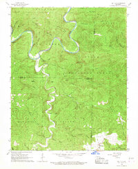
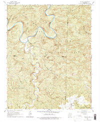
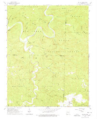
1966 Map of Big Flat
USGS Topo · Published 1967About this map
The Buffalo River carves a deep, winding path through this portion of the Arkansas Ozarks, defining the topography near the border of Marion and Baxter counties. In the mid-1960s, the small community of Big Flat serves as the primary settlement, anchored by a Cem and connected to the surrounding highlands via a network of unimproved roads and jeep trails like Rose Road and Farris Road. Much of the terrain is protected within the Ozark National Forest, where the landscape is marked by distinctive elevations such as Suggs Mountain, Almus Knob, and Tater Hill. The map reveals a drainage system defined by numerous hollows, including Barkshed Hollow and Woods Hollow, which feed into the main river system. This survey illustrates the era's balance between scattered rural homesteads and the vast, forested public lands that dominate the region.
Find a feature on this map
51 named features on this map. Tap any name to fly to it.
Don’t see what you’re looking for? This feature index may not catch every label — zoom into the map to look around manually.
Map Details
Editions of this 1966 Big Flat Map
3 editions found
Other maps of this area

1890 · Mountain Home
USGS Topo · 1:125,000

1891 · Mountain Home
USGS Topo · 1:125,000

1892 · Marshall
USGS Topo · 1:125,000

1892 · Mountain View
USGS Topo · 1:125,000

1893 · Yellville
USGS Topo · 1:125,000

1894 · Mountain View
USGS Topo · 1:125,000

1894 · Mountain Home
USGS Topo · 1:125,000

1894 · Marshall
USGS Topo · 1:125,000

1901 · Marshall
USGS Topo · 1:125,000

1903 · Yellville
USGS Topo · 1:125,000