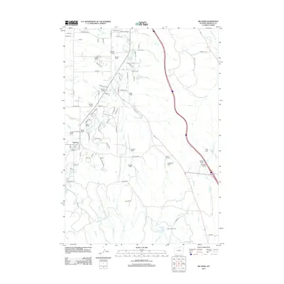
2012 Map of Big Horn
USGS Topo · Published 2012About this map
Big Horn serves as the focal point of this Sheridan County landscape, where the foothills meet a complex network of irrigation systems essential to Wyoming agriculture. The map documents an intricate water-management infrastructure, featuring named canals like the Gerdel Ditch, East Side Ditch, and the aptly named Last Chance Ditch. These waterways thread through the drainage basins of Little Goose Creek and Meade Creek, supporting ranches such as the Meade Creek Ranch.
Find a feature on this map
106 named features on this map. Tap any name to fly to it.
Don’t see what you’re looking for? This feature index may not catch every label — zoom into the map to look around manually.
Map Details
Editions of this 2012 Big Horn Map
This is the sole edition of this map. No revisions or reprints were ever made.
Other maps of this area

1895 · Dayton
USGS Topo · 1:125,000

1901 · Dayton
USGS Topo · 1:125,000

1909 · Sheridan
USGS Topo · 1:125,000

1911 · Sheridan
USGS Topo · 1:125,000

1955 · Sheridan
USGS Topo · 1:250,000

1958 · Sheridan
USGS Topo · 1:250,000

1962 · Sheridan
USGS Topo · 1:250,000
1964 · Hultz Draw
USGS Topo · 1:24,000
1964 · Beaver Creek Hills
USGS Topo · 1:24,000
1965 · Little Goose Peak
USGS Topo · 1:24,000