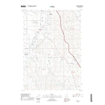
2017 Map of Big Horn
USGS Topo · Published 2017About this map
Little Goose Creek and a complex network of irrigation infrastructure define the landscape between the southern edge of Sheridan and the community of Big Horn. The terrain is deeply incised by family-named landmarks such as Jeffries Draw, Swaim Draw, and Stanko Draw, which channel runoff toward the major creeks. This 2017 survey reveals the extensive reliance on water management in this part of Wyoming, featuring numerous engineered waterways like the Ninemile Ditch, Burn Cleuch Ditch, and Last Chance Ditch. These ditches traverse the landscape to feed local agriculture and reservoirs, including Menardi and White Reservoir and Hanes Reservoir to the south. Local history is anchored by the Big Horn Cemetery, while the modern transportation corridor of Interstate 90 cuts through the eastern half of the map, contrasting with the rural network of named roads like Maverick Lane and Paradise Park Road.
Find a feature on this map
104 named features on this map. Tap any name to fly to it.
Don’t see what you’re looking for? This feature index may not catch every label — zoom into the map to look around manually.
Map Details
Editions of this 2017 Big Horn Map
This is the sole edition of this map. No revisions or reprints were ever made.
Other maps of this area

1895 · Dayton
USGS Topo · 1:125,000

1901 · Dayton
USGS Topo · 1:125,000

1909 · Sheridan
USGS Topo · 1:125,000

1911 · Sheridan
USGS Topo · 1:125,000

1955 · Sheridan
USGS Topo · 1:250,000

1958 · Sheridan
USGS Topo · 1:250,000

1962 · Sheridan
USGS Topo · 1:250,000
1964 · Hultz Draw
USGS Topo · 1:24,000
1964 · Beaver Creek Hills
USGS Topo · 1:24,000
1965 · Little Goose Peak
USGS Topo · 1:24,000