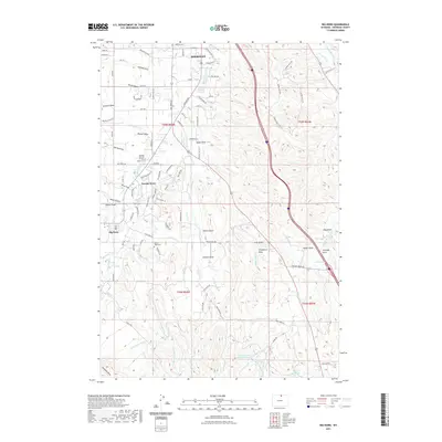
2021 Map of Big Horn
USGS Topo · Published 2021About this map
Sheridan and the community of Big Horn anchor this northern Wyoming landscape, where the plains meet the foothills of the Bighorn Mountains. The settlement pattern is defined by a sophisticated network of irrigation infrastructure essential for high-altitude ranching, including the Burn Cleuch Ditch, Meade Coffeen Ditch, and Last Chance Ditch. These man-made watercourses crisscross the natural drainage of Little Goose Cr and Meade Cr, supporting agricultural life in an arid environment. Near the southern edge of Sheridan, residential expansion and localized developments like Powder Horn contrast with more established sites like Mount Hope Cem. The terrain is deeply textured by named features like Stanko Draw, Johnson Draw, and Chapparal Draw, which channel seasonal runoff toward the valley floor. Water storage is managed through local catchments such as the Menardi and White Reservoir and Hanes Reservoir, marking the region's long-standing reliance on carefully managed water rights.
Find a feature on this map
94 named features on this map. Tap any name to fly to it.
Don’t see what you’re looking for? This feature index may not catch every label — zoom into the map to look around manually.
Map Details
Editions of this 2021 Big Horn Map
This is the sole edition of this map. No revisions or reprints were ever made.
Other maps of this area

1895 · Dayton
USGS Topo · 1:125,000

1901 · Dayton
USGS Topo · 1:125,000

1909 · Sheridan
USGS Topo · 1:125,000

1911 · Sheridan
USGS Topo · 1:125,000

1955 · Sheridan
USGS Topo · 1:250,000

1958 · Sheridan
USGS Topo · 1:250,000

1962 · Sheridan
USGS Topo · 1:250,000
1964 · Hultz Draw
USGS Topo · 1:24,000
1964 · Beaver Creek Hills
USGS Topo · 1:24,000
1965 · Little Goose Peak
USGS Topo · 1:24,000