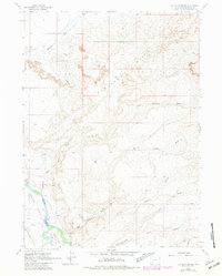
1963 Map of Big Island Bridge
USGS Topo · Published 1981About this map
The Green River flows through the southwestern corner of this landscape, creating a riparian corridor that contrasts sharply with the surrounding arid terrain. This area is home to the Seedskadee National Wildlife Refuge, established to protect the migratory bird routes and wetland habitats along the river’s path. The topography is dominated by the Badlands Hills, a complex network of eroded formations that feed a series of seasonal drainages, including Eightmile Wash and East Otterson Wash. A network of Jeep Trails provides the primary means of traversal through the interior, connecting remote landmarks and survey points like BM 6318. At the river's edge, the Big Island Bridge serves as a critical crossing point near Big Island, while a small Gravel Pit indicates localized resource extraction in an otherwise undeveloped expanse of Sweetwater County.
Find a feature on this map
21 named features on this map. Tap any name to fly to it.
Don’t see what you’re looking for? This feature index may not catch every label — zoom into the map to look around manually.
Map Details
Editions of this 1963 Big Island Bridge Map
2 editions found
Other maps of this area

1954 · Rock Springs
USGS Topo · 1:250,000

1958 · Rock Springs
USGS Topo · 1:250,000

1961 · Blue Point
USGS Topo · 1:24,000

1961 · Austin Ranch
USGS Topo · 1:24,000

1961 · Stevens Flat
USGS Topo · 1:24,000

1962 · Rock Springs
USGS Topo · 1:250,000

1963 · Gasson Bridge
USGS Topo · 1:24,000

1963 · Pittman Well
USGS Topo · 1:24,000

1963 · Big Island Bridge
USGS Topo · 1:24,000
1963 · Thoman School
USGS Topo · 1:24,000