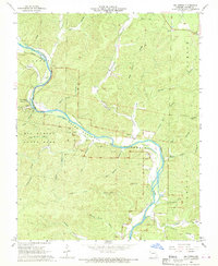
1968 Map of Big Spring
USGS Topo · Published 1969About this map
The Current River meanders through the heart of the Ozarks in this late-1960s survey, anchoring the recently authorized Ozark National Scenic Riverways. This map highlights a transition in land use, where the timber and rail era left behind an Old Railroad Grade and numerous hollows named for local families, such as Chub Hollow and McSpadden Hollow. The settlement of Chilton sits near the river, surrounded by sites of genealogical interest including Aldrich Valley Cem, Chilton Cem, and Kelley Cem. Industrial activity is represented by scattered Quarry locations, while the natural landscape is defined by features like Big Spring, Lost Man Cave, and Cave Spring. Aviation and water management are also present through the State Park Landing Strip and the Big Spring Gaging Station, showing how the area within Big Spring State Park was managed for both conservation and tourism.
Find a feature on this map
50 named features on this map. Tap any name to fly to it.
Don’t see what you’re looking for? This feature index may not catch every label — zoom into the map to look around manually.
Map Details
Editions of this 1968 Big Spring Map
3 editions found
Other maps of this area

1928 · Cardareva
USGS Topo · 1:62,500

1943 · Ellington
USGS Topo · 1:62,500

1944 · Van Buren
USGS Topo · 1:62,500

1944 · Grandin
USGS Topo · 1:62,500

1945 · Ellington
USGS Topo · 1:62,500

1946 · Grandin
USGS Topo · 1:62,500

1946 · Van Buren
USGS Topo · 1:62,500

1949 · Rolla
USGS Topo · 1:250,000

1949 · Cardareva
USGS Topo · 1:62,500

1953 · Rolla
USGS Topo · 1:250,000