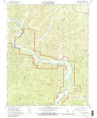
1968 Map of Big Spring
USGS Topo · Published 1980About this map
The Current River meanders through this portion of Carter County, shaping a landscape defined by its deep hollows and subterranean hydrology. This 1968 field survey documents the early years of the Ozark National Scenic Riverways, showing the integration of protected lands with existing local landmarks. The prominent Big Spring State Park serves as a focal point, featuring the Big Spring Gaging Station and the State Park Landing Strip along the river's edge.
Find a feature on this map
40 named features on this map. Tap any name to fly to it.
Don’t see what you’re looking for? This feature index may not catch every label — zoom into the map to look around manually.
Map Details
Editions of this 1968 Big Spring Map
3 editions found
Other maps of this area

1928 · Cardareva
USGS Topo · 1:62,500

1943 · Ellington
USGS Topo · 1:62,500

1944 · Van Buren
USGS Topo · 1:62,500

1944 · Grandin
USGS Topo · 1:62,500

1945 · Ellington
USGS Topo · 1:62,500

1946 · Grandin
USGS Topo · 1:62,500

1946 · Van Buren
USGS Topo · 1:62,500

1949 · Rolla
USGS Topo · 1:250,000

1949 · Cardareva
USGS Topo · 1:62,500

1953 · Rolla
USGS Topo · 1:250,000