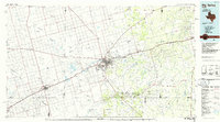
1986 Map of Big Spring
USGS Topo · Published 1986About this map
Big Spring serves as the central hub of this 1980s West Texas landscape, where the convergence of the Missouri Pacific railroad and regional highways mirrors the historic paths of the Sulphur Springs Draw and Mustang Draw. The map documents a period of significant petroleum activity, clearly delineating the vast Snyder Oil Field and the East Howard County Oil Field which dominate the central and eastern portions of the county.
Find a feature on this map
64 named features on this map. Tap any name to fly to it.
Don’t see what you’re looking for? This feature index may not catch every label — zoom into the map to look around manually.
Map Details
Editions of this 1986 Big Spring Map
2 editions found
Other maps of this area

1941 · Morita
USGS Topo · 1:62,500

1941 · Big Spring South
USGS Topo · 1:62,500

1942 · Big Spring South
USGS Topo · 1:62,500

1942 · Big Spring North
USGS Topo · 1:62,500

1949 · Morita
USGS Topo · 1:62,500

1950 · Cedar Bend
USGS Topo · 1:24,000

1950 · Lake Colorado City
USGS Topo · 1:24,000

1951 · Ira SW
USGS Topo · 1:24,000

1951 · Ira
USGS Topo · 1:24,000

1951 · Dunn
USGS Topo · 1:24,000