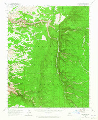
1958 Map of Big Springs
USGS Topo · Published 1965About this map
Big Springs and the surrounding high plateau of the Kaibab National Forest dominate this mid-century landscape, characterized by an intricate network of drainages and seasonal water sources. The map identifies the Ryan (Site) and essential forest camps such as Moquitch Camp and Pine Flat Camp, which served as hubs for range management and forestry operations. The terrain is deeply incised by Snake Gulch and Jacob Canyon, while the local topography is defined by prominent landmarks like Pigeon Point and Table Rock. A significant presence of springs and tanks, including Mourning Dove Spring, Mangum Springs, and Table Rock Tank, underscores the critical importance of water management in this arid timberland. The inclusion of the Game Preserve Boundary reflects the region's historical role in wildlife conservation and resource protection during the late 1950s.
Find a feature on this map
73 named features on this map. Tap any name to fly to it.
Don’t see what you’re looking for? This feature index may not catch every label — zoom into the map to look around manually.
Map Details
Editions of this 1958 Big Springs Map
3 editions found

Other maps of this area

1886 · Kaibab
USGS Topo · 1:250,000

1936 · Jacobs Lake
USGS Topo · 1:48,000

1940 · Jacob Lake
USGS Topo · 1:62,500

1953 · Jacobs Lake
USGS Topo · 1:62,500

1953 · Grand Canyon
USGS Topo · 1:250,000

1954 · Fredonia
USGS Topo · 1:62,500

1957 · Grand Canyon
USGS Topo · 1:250,000

1957 · Shinarump SE
USGS Topo · 1:24,000
1957 · House Rock Spring SW
USGS Topo · 1:24,000

1957 · Shinarump SW
USGS Topo · 1:24,000