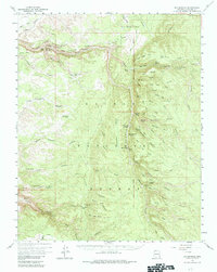
1958 Map of Big Springs
USGS Topo · Published 1984About this map
The high plateau and canyon country of the Kaibab National Forest dominate this landscape, characterized by an intricate network of drainage systems like Snake Gulch and Moquitch Canyon. The map reveals a history of human activity integrated into this difficult terrain, from the ancient Petroglyphs and unnamed Ruins in the northern ridges to the 20th-century operations at the Big Springs Ranger Station. Water sources are the defining landmarks for navigation and survival, noted by the density of named features like Toothpick Spring, Warm Springs, and Mourning Dove Spring.
Find a feature on this map
87 named features on this map. Tap any name to fly to it.
Don’t see what you’re looking for? This feature index may not catch every label — zoom into the map to look around manually.
Map Details
Editions of this 1958 Big Springs Map
3 editions found

Other maps of this area

1886 · Kaibab
USGS Topo · 1:250,000

1936 · Jacobs Lake
USGS Topo · 1:48,000

1940 · Jacob Lake
USGS Topo · 1:62,500

1953 · Jacobs Lake
USGS Topo · 1:62,500

1953 · Grand Canyon
USGS Topo · 1:250,000

1954 · Fredonia
USGS Topo · 1:62,500

1957 · Grand Canyon
USGS Topo · 1:250,000

1957 · Shinarump SE
USGS Topo · 1:24,000
1957 · House Rock Spring SW
USGS Topo · 1:24,000

1957 · Shinarump SW
USGS Topo · 1:24,000