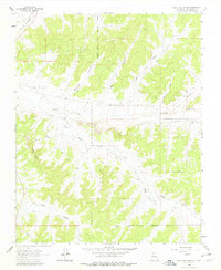
1963 Map of Billy Rice Canyon
USGS Topo · Published 1978About this map
Jicarilla Apache Indian Reservation Boundary defines the eastern and southern edges of this mid-century Rio Arriba landscape. The region is characterized by deep drainage systems and isolated homesteads, including Schmitz Ranch and Leeson Ranch in the north and Post Ranch and Black Ranch further east. The transition from the rugged Adobe Knobs to the broad wash of Cañada Larga illustrates the complex hydrology of the high desert, where water management is critical for the local ranching economy. Industrial activity is marked by a network of pipelines and several gas wells and drill holes, indicating the intersection of traditional livestock grazing with expanding energy exploration in the 1960s. These developments follow the natural contours of terrain features like Billy Rice Canyon and Medio Canyon, revealing how geography dictated the placement of both historic homesteads and modern infrastructure.
Find a feature on this map
21 named features on this map. Tap any name to fly to it.
Don’t see what you’re looking for? This feature index may not catch every label — zoom into the map to look around manually.
Map Details
Editions of this 1963 Billy Rice Canyon Map
2 editions found
Other maps of this area

1889 · Largo
USGS Topo · 1:250,000

1895 · Largo
USGS Topo · 1:250,000

1954 · Aztec
USGS Topo · 1:250,000

1958 · Aztec
USGS Topo · 1:250,000

1962 · Aztec
USGS Topo · 1:250,000

1963 · Lapis Point
USGS Topo · 1:24,000

1963 · Schmitz Ranch
USGS Topo · 1:24,000

1963 · Otero Store
USGS Topo · 1:24,000

1963 · Lindrith
USGS Topo · 1:24,000
1963 · Ojito
USGS Topo · 1:24,000