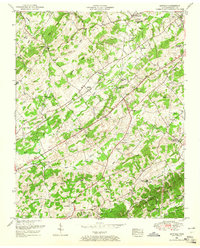
1952 Map of Binfield
USGS Topo · Published 1965About this map
Binfield and the surrounding Blount County countryside appear here as a landscape of small agricultural communities and numerous country parishes during the early 1950s. The region is defined by a series of parallel ridges, including Spradling Ridge and Hutton Ridge, which channel the flow of Baker Creek and Pistol Creek. The Louisville and Nashville railroad cuts a diagonal path through the center of the sheet, providing a vital transportation link for settlements like Clover Hill and Alnwick.
Find a feature on this map
54 named features on this map. Tap any name to fly to it.
Don’t see what you’re looking for? This feature index may not catch every label — zoom into the map to look around manually.
Map Details
Editions of this 1952 Binfield Map
4 editions found
Other maps of this area

1886 · Knoxville
USGS Topo · 1:125,000

1892 · Knoxville
USGS Topo · 1:125,000

1894 · Knoxville
USGS Topo · 1:125,000

1895 · Loudon
USGS Topo · 1:125,000

1895 · Knoxville
USGS Topo · 1:125,000

1901 · Knoxville
USGS Topo · 1:125,000

1935 · Binfield
USGS Topo · 1:24,000

1935 · Knoxville
USGS Topo · 1:48,000

1935 · Meadow
USGS Topo · 1:24,000

1935 · Maryville
USGS Topo · 1:24,000