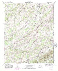
1952 Map of Binfield
USGS Topo · Published 1981About this map
The rolling agricultural landscape of rural Blount County is anchored by the community of Binfield and the industrial landmark of Brick Mill. This 1952 survey shows a network of family-named ridges and hollows, such as Spradling Ridge and Mutton Hollow, which dictated the early settlement patterns of the region. The area is dense with community pillars, including numerous rural congregations and schools such as Baker Creek Church and the Fairview School. Near the village of Alnwick, the County farm and Laurel Bank Cemetery represent deep-rooted local history.
Find a feature on this map
57 named features on this map. Tap any name to fly to it.
Don’t see what you’re looking for? This feature index may not catch every label — zoom into the map to look around manually.
Map Details
Editions of this 1952 Binfield Map
4 editions found
Other maps of this area

1886 · Knoxville
USGS Topo · 1:125,000

1892 · Knoxville
USGS Topo · 1:125,000

1894 · Knoxville
USGS Topo · 1:125,000

1895 · Loudon
USGS Topo · 1:125,000

1895 · Knoxville
USGS Topo · 1:125,000

1901 · Knoxville
USGS Topo · 1:125,000

1935 · Binfield
USGS Topo · 1:24,000

1935 · Knoxville
USGS Topo · 1:48,000

1935 · Meadow
USGS Topo · 1:24,000

1935 · Maryville
USGS Topo · 1:24,000