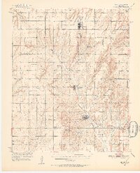
1951 Map of Binger
USGS Topo · Published 1952About this map
Binger and Lookeba serve as focal points for this agricultural region in the early 1950s, where a dense network of country schools and community centers suggests a closely-knit rural population. The landscape is deeply etched by a system of south-flowing drainages including Sugar Creek and Kickapoo Creek, which eventually feed toward the Canadian River in the northeast. This era shows the persistence of small-scale educational districts, evidenced by named facilities like Mound Sch, Prairie Dale Sch, and Fern Sch.
Find a feature on this map
46 named features on this map. Tap any name to fly to it.
Don’t see what you’re looking for? This feature index may not catch every label — zoom into the map to look around manually.
Map Details
Editions of this 1951 Binger Map
3 editions found
Other maps of this area

1893 · Fort Reno
USGS Topo · 1:62,500

1893 · Buggy Creek
USGS Topo · 1:62,500

1941 · Fort Reno
USGS Topo · 1:62,500

1942 · Fort Reno
USGS Topo · 1:62,500

1942 · Geary
USGS Topo · 1:62,500

1945 · Anadarko
USGS Topo · 1:62,500

1949 · Fort Reno
USGS Topo · 1:62,500

1951 · Binger
USGS Topo · 1:62,500

1951 · Fort Cobb
USGS Topo · 1:62,500

1955 · Clinton
USGS Topo · 1:250,000