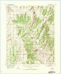
1951 Map of Binger
USGS Topo · Published 1971About this map
Sugar Creek and its many tributaries, including Kickapoo Creek and Medicine Creek, carve a complex drainage pattern through Caddo County. This 1951 survey records the agricultural and civic layout of central Oklahoma during the mid-century, centered on the towns of Hinton, Binger, and Lookeba. The landscape is dotted with a dense network of country schools, such as Sickles Sch, Pleasant View Sch, and Oakdale Sch, reflecting a time when rural education was highly localized. The northern edge of the map follows the course of the Canadian River, while the southern reaches highlight landmarks like the Indian Community House and Three-Way Corner. This document provides a clear view of the area's transition from open terrain into the established settlements of Waconda and Sickles townships, preserving the locations of family-named schools and cemeteries like Binger Cem before further consolidation changed the local geography.
Find a feature on this map
41 named features on this map. Tap any name to fly to it.
Don’t see what you’re looking for? This feature index may not catch every label — zoom into the map to look around manually.
Map Details
Editions of this 1951 Binger Map
3 editions found
Other maps of this area

1893 · Fort Reno
USGS Topo · 1:62,500

1893 · Buggy Creek
USGS Topo · 1:62,500

1941 · Fort Reno
USGS Topo · 1:62,500

1942 · Fort Reno
USGS Topo · 1:62,500

1942 · Geary
USGS Topo · 1:62,500

1945 · Anadarko
USGS Topo · 1:62,500

1949 · Fort Reno
USGS Topo · 1:62,500

1951 · Binger
USGS Topo · 1:62,500

1951 · Fort Cobb
USGS Topo · 1:62,500

1955 · Clinton
USGS Topo · 1:250,000