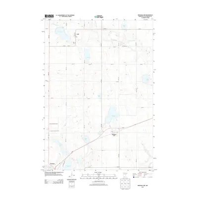
2013 Map of Bingham Lake
USGS Topo · Published 2013About this map
The Watonwan River meanders through this agricultural landscape in southern Minnesota, anchoring a region defined by its numerous prairie lakes and the expanding footprint of Windom. This 2013 survey illustrates the established infrastructure of Cottonwood County, where the small settlement of Delft and the city of Bingham Lake serve as local hubs connected by a grid of section-line roads like Co Hwy-13. Significant for genealogists, the map preserves the locations of several burial grounds, including Delft Cem, Carson Cem, and Voth Cem, reflecting the area's rural community history. The southwestern corner is particularly active, showing the proximity of the Windom Municipal Airport to Resthaven Memory Gardens and the shores of Cottonwood Lake, highlighting the intersection of municipal development and the natural hydrology of the glaciated plains.
Find a feature on this map
32 named features on this map. Tap any name to fly to it.
Don’t see what you’re looking for? This feature index may not catch every label — zoom into the map to look around manually.
Map Details
Editions of this 2013 Bingham Lake Map
This is the sole edition of this map. No revisions or reprints were ever made.
Other maps of this area

1953 · New Ulm
USGS Topo · 1:250,000

1954 · Fairmont
USGS Topo · 1:250,000

1957 · New Ulm
USGS Topo · 1:250,000

1958 · New Ulm
USGS Topo · 1:250,000

1958 · Fairmont
USGS Topo · 1:250,000

1967 · New Ulm
USGS Topo · 1:250,000

1967 · Sanborn SE
USGS Topo · 1:24,000

1967 · Jeffers
USGS Topo · 1:24,000
1967 · Comfrey
USGS Topo · 1:24,000
1970 · Bingham Lake
USGS Topo · 1:24,000