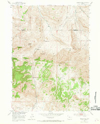
1951 Map of Birdseye Pass
USGS Topo · Published 1969About this map
Copper Mountain dominates the landscape in this mid-century survey of the rugged heights along the boundary of Hot Springs and Fremont counties. The map documents a fading era of high-altitude extraction and habitation, most notably at the Birdseye Station (Abandoned) and nearby Birdseye Ranch. The terrain is carved by numerous watercourses, including Tough Creek and Cottonwood Creek, which flow through deep basins like Woods Basin.
Find a feature on this map
22 named features on this map. Tap any name to fly to it.
Don’t see what you’re looking for? This feature index may not catch every label — zoom into the map to look around manually.
Map Details
Editions of this 1951 Birdseye Pass Map
3 editions found
Other maps of this area

1950 · Bonneville SW
USGS Topo · 1:24,000

1951 · Boysen
USGS Topo · 1:24,000

1951 · Birdseye Pass
USGS Topo · 1:24,000

1951 · Bonneville
USGS Topo · 1:24,000

1952 · Picard Ranch
USGS Topo · 1:24,000

1952 · Guffy Peak
USGS Topo · 1:24,000

1955 · Thermopolis
USGS Topo · 1:250,000

1955 · Arminto
USGS Topo · 1:250,000
1957 · Bonneville
USGS Topo · 1:24,000

1958 · Thermopolis
USGS Topo · 1:250,000