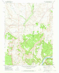
1970 Map of Bitter Creek Well
USGS Topo · Published 1973About this map
The Bitter Creek Well (Flowing) serves as a primary landmark in this 1970 landscape, where the high desert terrain is defined by complex drainage systems and early transportation corridors. This borderland region between Grand County, Utah, and Mesa County, Colorado, is marked by an extensive Old Railroad Grade and an Old Grade that parallel the winding Bitter Creek. These industrial remnants, alongside several noted Drill Holes and Borrow Pits, indicate a history of resource exploration and engineering through the canyons and valleys.
Find a feature on this map
22 named features on this map. Tap any name to fly to it.
Don’t see what you’re looking for? This feature index may not catch every label — zoom into the map to look around manually.
Map Details
Editions of this 1970 Bitter Creek Well Map
4 editions found
Other maps of this area

1885 · East Tavaputs
USGS Topo · 1:250,000

1954 · Westwater 4 SW
USGS Topo · 1:24,000

1956 · Westwater 4 SE
USGS Topo · 1:24,000

1956 · Grand Junction
USGS Topo · 1:250,000

1959 · Grand Junction
USGS Topo · 1:250,000

1960 · Grand Junction
USGS Topo · 1:250,000

1962 · Grand Junction
USGS Topo · 1:250,000

1964 · Grand Junction
USGS Topo · 1:250,000

1965 · Grand Junction
USGS Topo · 1:250,000

1968 · Badger Wash
USGS Topo · 1:24,000