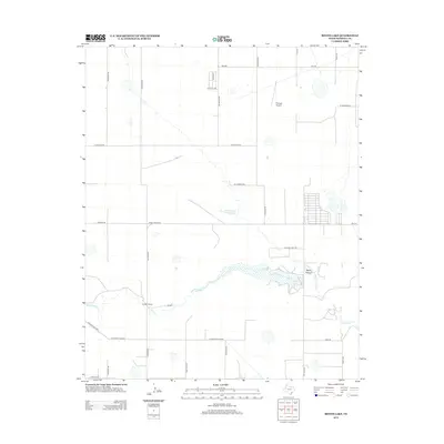
2012 Map of Bivins Lake
USGS Topo · Published 2012About this map
Palo Duro Cr cuts a winding path across this portion of Randall County, anchoring a landscape defined by ranching operations and water management. The terrain is marked by the presence of Forrester Ranch and the Tom Gerald Ranch-Lake, illustrating the importance of private landholdings in the development of the region. The central focal point is Bivins Lake, which receives drainage from the Negro Arroyo to the north. Transportation and connectivity are provided by a grid of rural routes including Ranch Road 2219 and FM-168, while the Flying K Airport serves as a distinct aviation landmark in the northeastern quadrant. Suburban growth is hinted at by the street layouts appearing near Laguna Vista Rd, showing the gradual expansion of residential footprints into the traditional ranchlands south of Amarillo.
Find a feature on this map
29 named features on this map. Tap any name to fly to it.
Don’t see what you’re looking for? This feature index may not catch every label — zoom into the map to look around manually.
Map Details
Editions of this 2012 Bivins Lake Map
This is the sole edition of this map. No revisions or reprints were ever made.
Other maps of this area

1954 · Tucumcari
USGS Topo · 1:250,000

1954 · Amarillo
USGS Topo · 1:250,000

1954 · Plainview
USGS Topo · 1:250,000

1954 · Clovis
USGS Topo · 1:250,000

1958 · Clovis
USGS Topo · 1:250,000

1958 · Amarillo
USGS Topo · 1:250,000

1958 · Tucumcari
USGS Topo · 1:250,000

1958 · Plainview
USGS Topo · 1:250,000

1960 · Canyon
USGS Topo · 1:62,500
1960 · Amarillo West
USGS Topo · 1:24,000