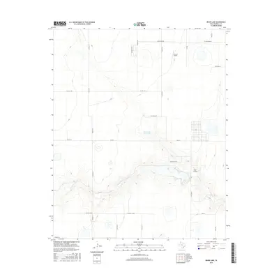
2016 Map of Bivins Lake
USGS Topo · Published 2016About this map
Palo Duro Cr cuts through this portion of the Texas Panhandle, defining a landscape of canyons and drainage patterns southeast of the modern ranching and residential developments. The area is characterized by scattered water features including Bivins Lake and the Tom Gerald Ranch Lake, which serve as critical landmarks in this arid environment. The road network, including Fm 2219 and W Country Club Rd, reveals the gradual transition from open range to organized rural subdivisions. Aviation history is noted by the presence of the Flying K Airport situated north of the canyon breaks. Notable topographic features like Negro Arroyo emphasize the erosional forces that have shaped the terrain, while roads such as Sampson Rd and Hunsley Rd provide the framework for contemporary land use in Randall County.
Find a feature on this map
24 named features on this map. Tap any name to fly to it.
Don’t see what you’re looking for? This feature index may not catch every label — zoom into the map to look around manually.
Map Details
Editions of this 2016 Bivins Lake Map
This is the sole edition of this map. No revisions or reprints were ever made.
Other maps of this area

1954 · Tucumcari
USGS Topo · 1:250,000

1954 · Amarillo
USGS Topo · 1:250,000

1954 · Plainview
USGS Topo · 1:250,000

1954 · Clovis
USGS Topo · 1:250,000

1958 · Clovis
USGS Topo · 1:250,000

1958 · Amarillo
USGS Topo · 1:250,000

1958 · Tucumcari
USGS Topo · 1:250,000

1958 · Plainview
USGS Topo · 1:250,000

1960 · Canyon
USGS Topo · 1:62,500
1960 · Amarillo West
USGS Topo · 1:24,000