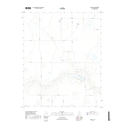
2019 Map of Bivins Lake
USGS Topo · Published 2019About this map
Palo Duro Creek carves a deep path across this High Plains landscape, creating a dramatic break in the topography that defines the local geography south of Amarillo. The waterway flows through Bivins Lake, a central feature that serves as a focal point for the surrounding canyon and ranch lands. The map illustrates a transitional environment where traditional ranching landmarks like Tom Gerald Ranch Lake and the drainage of Negro Arroyo coexist with modern residential and recreational developments. These newer patterns are evident in the structured road networks of Laguna Vista Rd and W Country Club Rd. Aviation history in this corner of Randall County is represented by the Flying K Airport, while the intricate contour lines reveal the complex erosion patterns that lead into the larger canyon systems of the Texas Panhandle.
Find a feature on this map
25 named features on this map. Tap any name to fly to it.
Don’t see what you’re looking for? This feature index may not catch every label — zoom into the map to look around manually.
Map Details
Editions of this 2019 Bivins Lake Map
This is the sole edition of this map. No revisions or reprints were ever made.
Other maps of this area

1954 · Tucumcari
USGS Topo · 1:250,000

1954 · Amarillo
USGS Topo · 1:250,000

1954 · Plainview
USGS Topo · 1:250,000

1954 · Clovis
USGS Topo · 1:250,000

1958 · Clovis
USGS Topo · 1:250,000

1958 · Amarillo
USGS Topo · 1:250,000

1958 · Tucumcari
USGS Topo · 1:250,000

1958 · Plainview
USGS Topo · 1:250,000

1960 · Canyon
USGS Topo · 1:62,500
1960 · Amarillo West
USGS Topo · 1:24,000