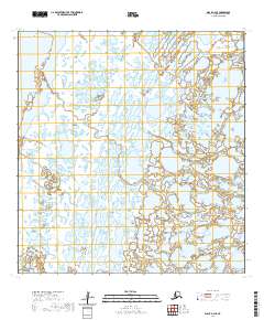
2020 Map of Black A-2 SE
USGS Topo · Published 2020About this map
The vast, water-heavy landscape of the Yukon-Kuskokwim Delta meets the eastern edge of the Bering Sea in this 2020 topographic study. The terrain is dominated by a complex network of wetlands and shallow lakes typical of this low-lying coastal region. Melatorik Creek winds through the northeast corner of the quadrangle, serving as one of the few named drainage features in an otherwise saturated and trackless expanse. The map illustrates the extreme tidal and alluvial nature of the Kusilvak Census Area, where land and water are intricately entwined. Without any roads, settlements, or infrastructure indicated, the survey emphasizes the remote and natural state of the coastal tundra, defined largely by its legal land partitions under the Public Land Survey System including t23n r89w and t24n r90w.
Find a feature on this map
9 named features on this map. Tap any name to fly to it.
Don’t see what you’re looking for? This feature index may not catch every label — zoom into the map to look around manually.
Map Details
Editions of this 2020 Black A-2 SE Map
This is the sole edition of this map. No revisions or reprints were ever made.
Other maps of this area

1951 · Hooper Bay
USGS Topo · 1:250,000

1951 · Black
USGS Topo · 1:250,000

1952 · Black A-2
USGS Topo · 1:63,360

1952 · Black A-1
USGS Topo · 1:63,360

1952 · Hooper Bay D-2
USGS Topo · 1:63,360

1953 · Hooper Bay
USGS Topo · 1:250,000
1953 · Hooper Bay D-3
USGS Topo · 1:63,360

1964 · Hooper Bay
USGS Topo · 1:250,000
2020 · Black A-2 SW
USGS Topo · 1:25,000
2020 · Black A-1 SW
USGS Topo · 1:25,000