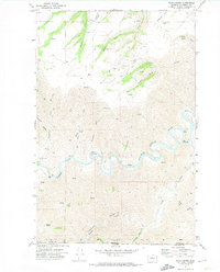
1971 Map of Black Butte
USGS Topo · Published 1974About this map
The Grande Ronde River carves a deep, winding path through the canyonlands of Asotin County in the early 1970s, marking the dramatic borderland between Washington and Oregon. This landscape is defined by its verticality, where high features like Weissenfels Ridge and Black Butte overlook a complex network of drainage systems including Joseph Creek and Tenmile Creek. Human activity is sparse but telling, concentrated along scattered jeep trails and the small settlement area of Shumaker.
Find a feature on this map
28 named features on this map. Tap any name to fly to it.
Don’t see what you’re looking for? This feature index may not catch every label — zoom into the map to look around manually.
Map Details
Editions of this 1971 Black Butte Map
2 editions found
Other maps of this area

1944 · Anatone
USGS Topo · 1:62,500

1946 · Limekiln Rapids
USGS Topo · 1:62,500

1946 · Anatone
USGS Topo · 1:62,500

1955 · Pullman
USGS Topo · 1:250,000

1955 · Grangeville
USGS Topo · 1:250,000

1958 · Pullman
USGS Topo · 1:250,000

1959 · Grangeville
USGS Topo · 1:250,000

1963 · Jim Creek Butte
USGS Topo · 1:24,000
1967 · Paradise
USGS Topo · 1:24,000
1967 · Teepee Butte
USGS Topo · 1:24,000