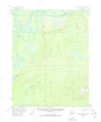
1956 Map of Black River D-5
USGS Topo · Published 1975About this map
The Porcupine River dominates the northern reaches of this Alaskan interior landscape, carving a complex network of waterways including Rock Slough and Henderson Slough. Near the river's bend sits John Herberts Village, a notable settlement point adjacent to a Gaging Sta. The terrain transitions from the low-lying wetlands and lakes of the river valley, such as Wolverine Lake and Scotty Lake, to the significant elevation of Frozen Calf Mountain in the southeast.
Find a feature on this map
14 named features on this map. Tap any name to fly to it.
Don’t see what you’re looking for? This feature index may not catch every label — zoom into the map to look around manually.
Map Details
Editions of this 1956 Black River D-5 Map
2 editions found
Other maps of this area

1951 · Black River
USGS Topo · 1:250,000

1951 · Coleen
USGS Topo · 1:250,000

1956 · Coleen
USGS Topo · 1:250,000

1956 · Black River D-6
USGS Topo · 1:63,360

1956 · Coleen A-5
USGS Topo · 1:63,360

1956 · Black River D-4
USGS Topo · 1:63,360

1956 · Black River D-5
USGS Topo · 1:63,360

1956 · Black River C-6
USGS Topo · 1:63,360
1956 · Coleen A-6
USGS Topo · 1:63,360

1956 · Black River C-5
USGS Topo · 1:63,360