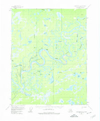
1956 Map of Black River D-6
USGS Topo · Published 1974About this map
The winding Porcupine River and Black River dominate this interior Alaskan landscape, characterized by an intricate network of sloughs and floodplain lakes. In the mid-1950s, the area remained largely a wilderness shaped by shifting waterways, with human activity centered on isolated outposts. Notable structures include the Shuman House perched near the river bend and the Joe Ward Camp situated along the Joe Ward Slough.
Find a feature on this map
32 named features on this map. Tap any name to fly to it.
Don’t see what you’re looking for? This feature index may not catch every label — zoom into the map to look around manually.
Map Details
Editions of this 1956 Black River D-6 Map
3 editions found
Other maps of this area

1951 · Fort Yukon
USGS Topo · 1:250,000

1951 · Black River
USGS Topo · 1:250,000

1951 · Coleen
USGS Topo · 1:250,000

1951 · Christian
USGS Topo · 1:250,000

1956 · Coleen
USGS Topo · 1:250,000

1956 · Fort Yukon C-1
USGS Topo · 1:63,360

1956 · Black River D-6
USGS Topo · 1:63,360

1956 · Coleen A-5
USGS Topo · 1:63,360

1956 · Black River D-5
USGS Topo · 1:63,360

1956 · Black River C-6
USGS Topo · 1:63,360