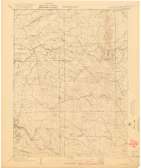
1906 Map of Blackhawk
USGS Topo · Published 1916About this map
Pine Glade School and a network of family-named ranches anchor this high-altitude landscape during a period of significant railway expansion and mining interest. The western edge highlights the corridor between Rollinsville and Pactolus, where the Denver Northwestern and Pacific rail line follows the winding course of South Boulder Creek. Local agricultural life is represented by numerous holdings such as Winiger Ranch, Skate Ranch, and Benson Ranch, situated along the gulches and creeks that drain toward the foothills.
Find a feature on this map
84 named features on this map. Tap any name to fly to it.
Don’t see what you’re looking for? This feature index may not catch every label — zoom into the map to look around manually.
Map Details
Editions of this 1906 Blackhawk Map
5 editions found
Other maps of this area

1899 · West Denver
USGS Topo · 1:125,000

1902 · Boulder
USGS Topo · 1:62,500

1903 · Georgetown
USGS Topo · 1:62,500

1904 · Niwot
USGS Topo · 1:62,500

1904 · Boulder
USGS Topo · 1:62,500

1905 · Central City
USGS Topo · 1:62,500

1905 · Georgetown
USGS Topo · 1:62,500

1906 · Blackhawk
USGS Topo · 1:62,500

1910 · Central City
USGS Topo · 1:62,500

1912 · Central City
USGS Topo · 1:62,500